Olomouc III.stage of flood protection

1st Prize
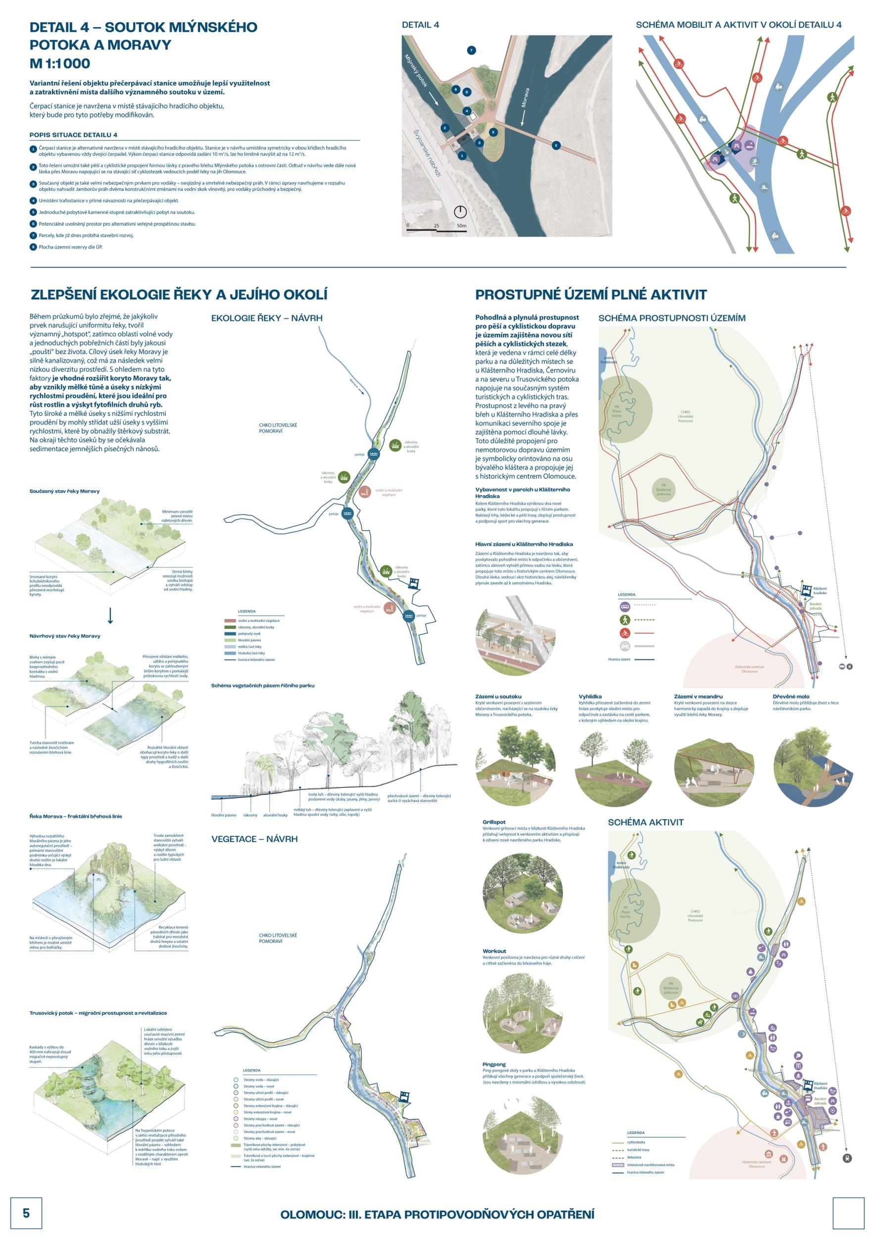
  • Author gogolák + grasse
  • Team Ivan Gogolák, Lukáš Grasse, Michaela Jandeková, Martina Havlová, Radek Prokeš, Miloslav Šindlar, Jan Zapletal, Jakub Kološ, Martin Sucharda, Matúš Berák, Karolína Čechová, Milan Kubeš, Štěpán Matějka, Petr Staněk, Milan Šuška
  • Prague
Annotation

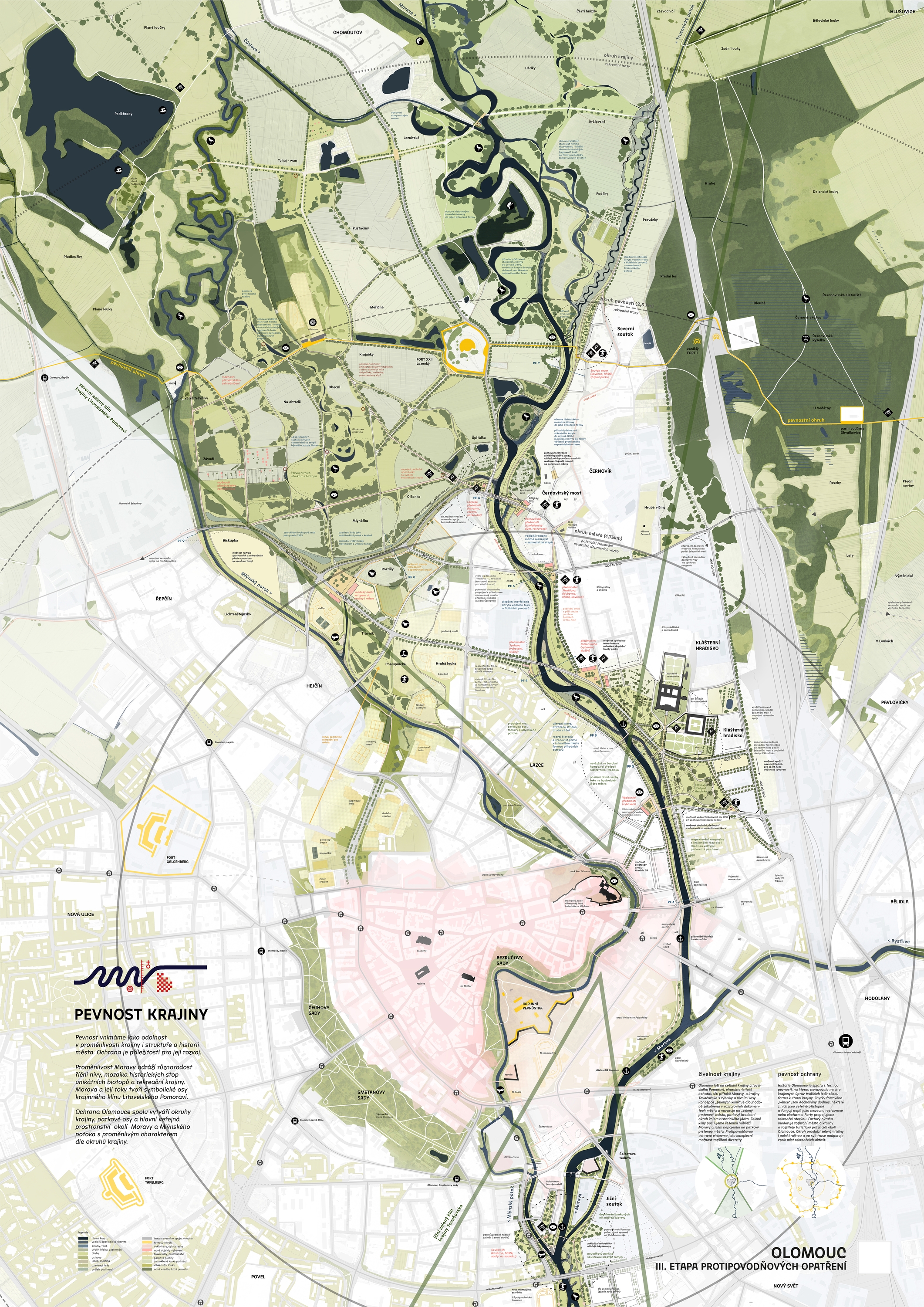
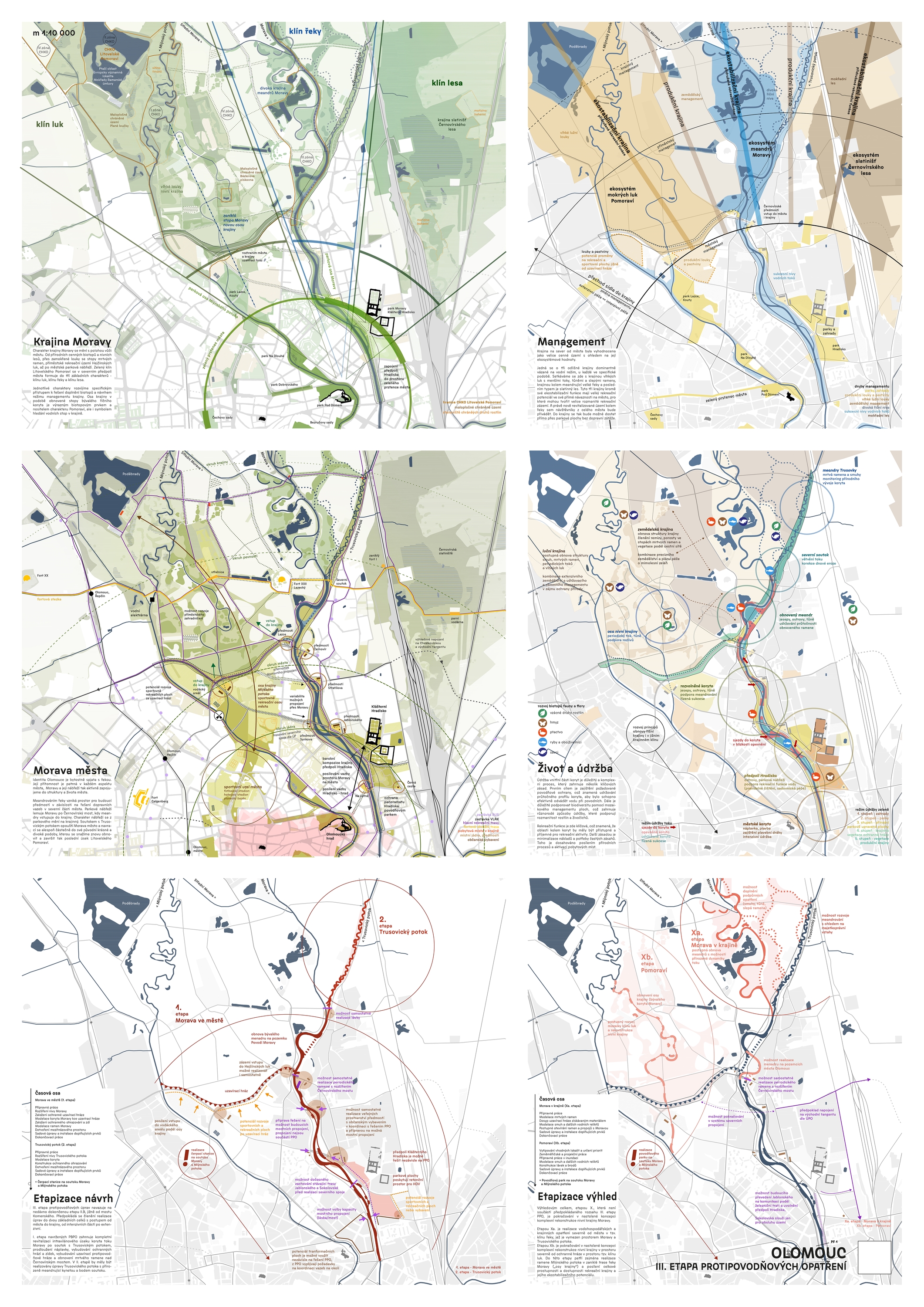
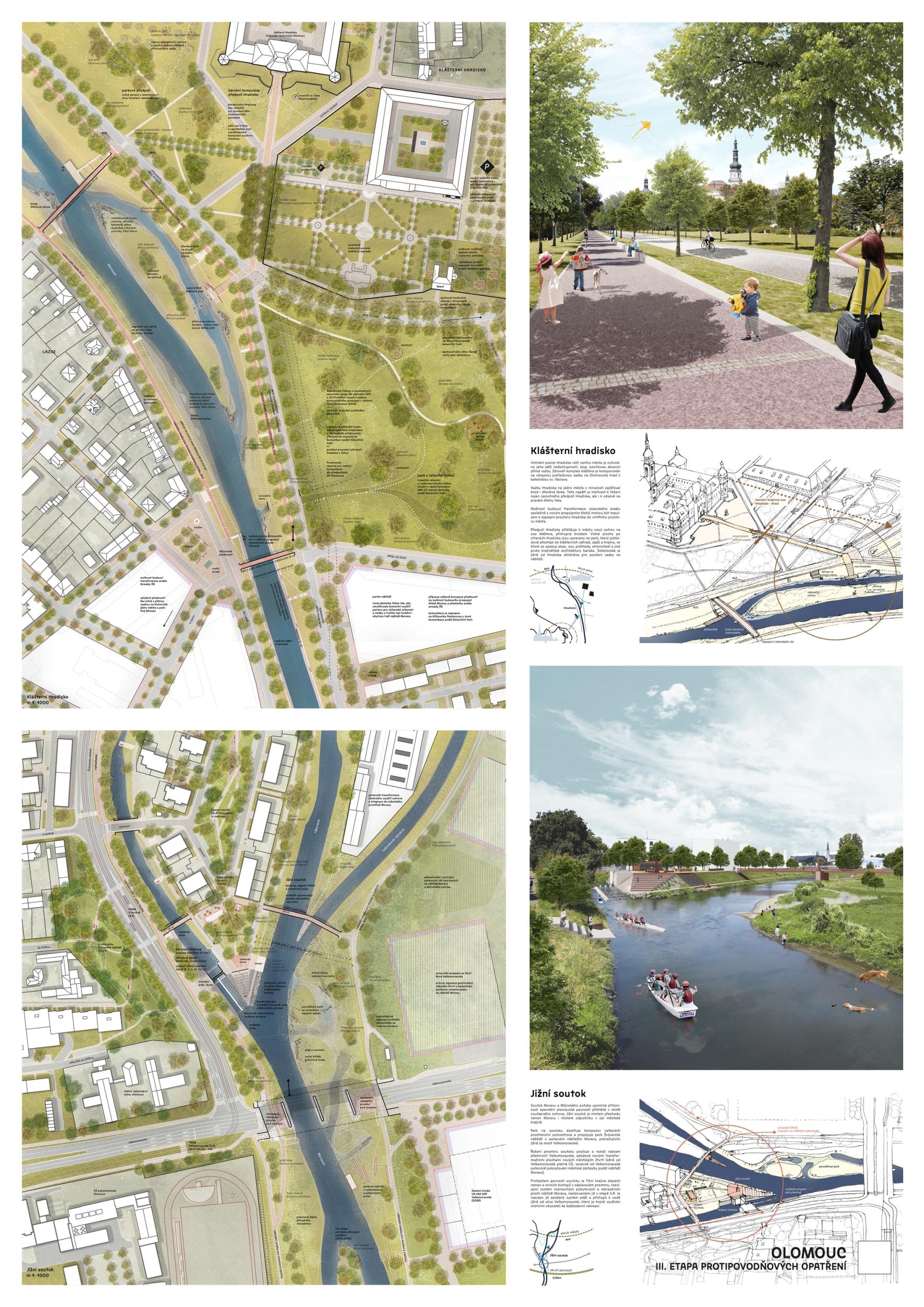
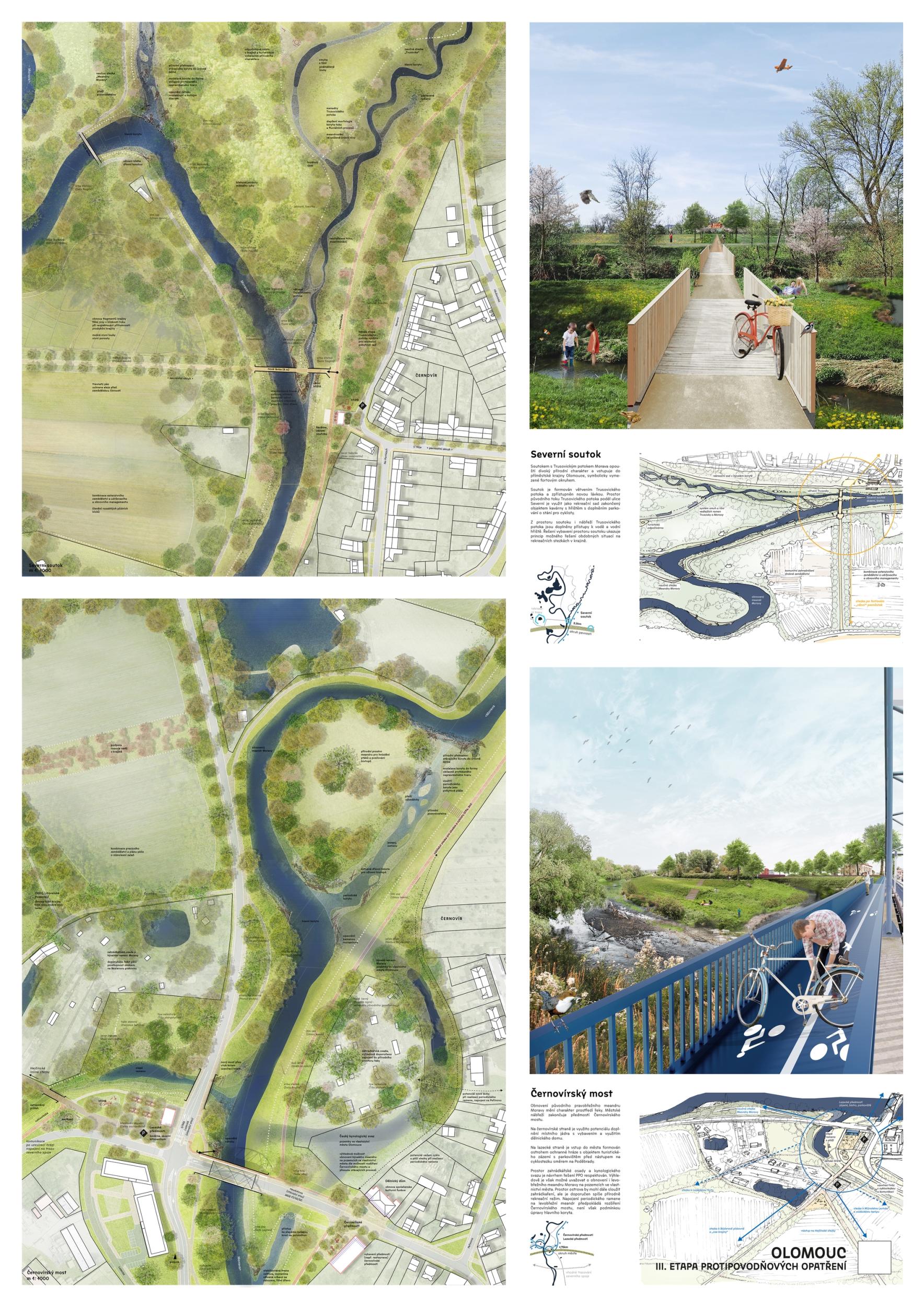
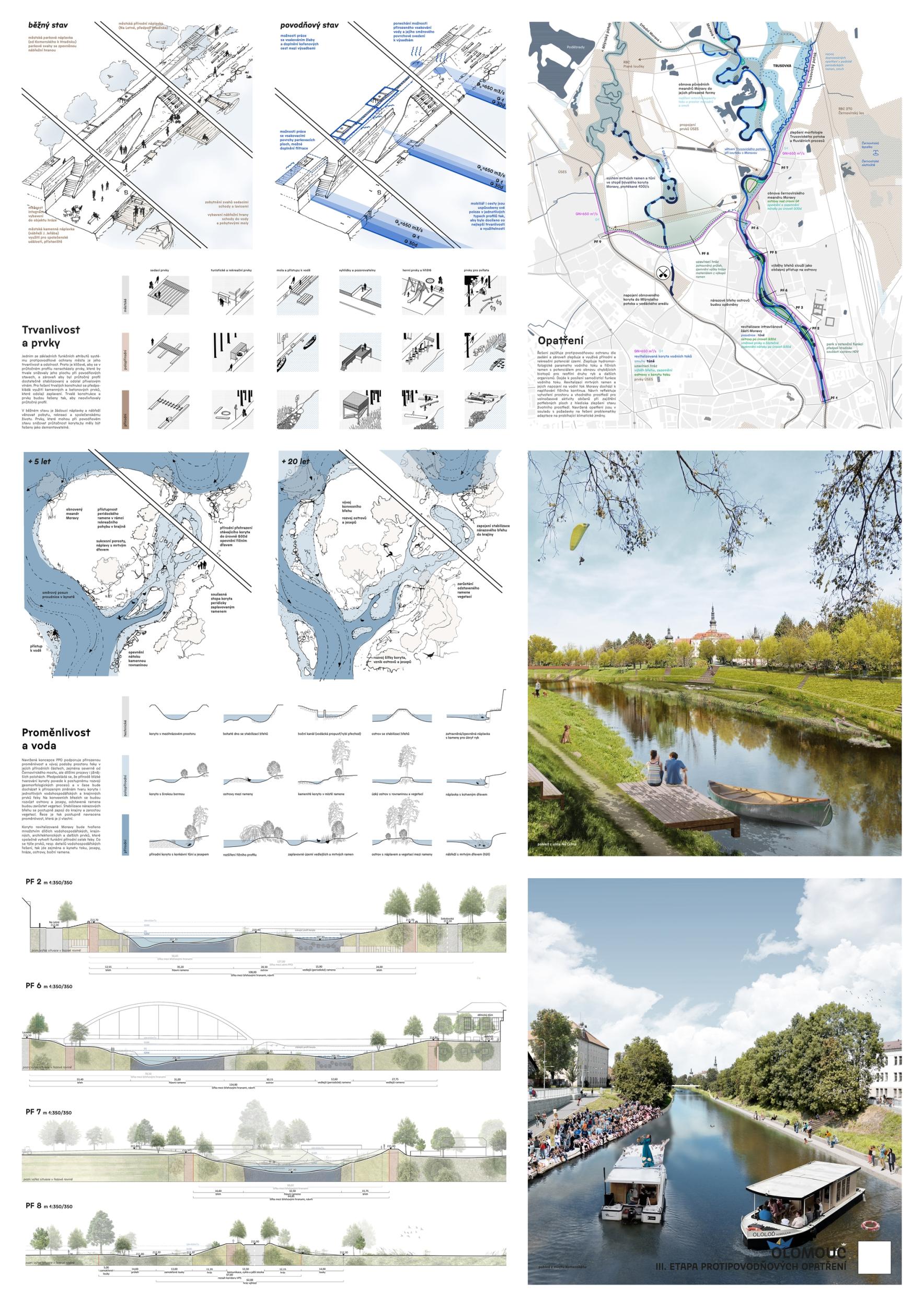
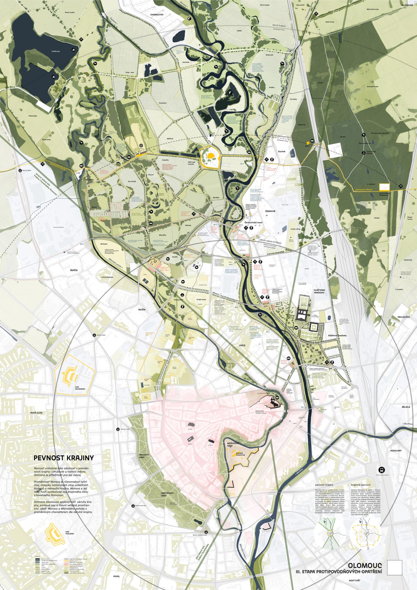
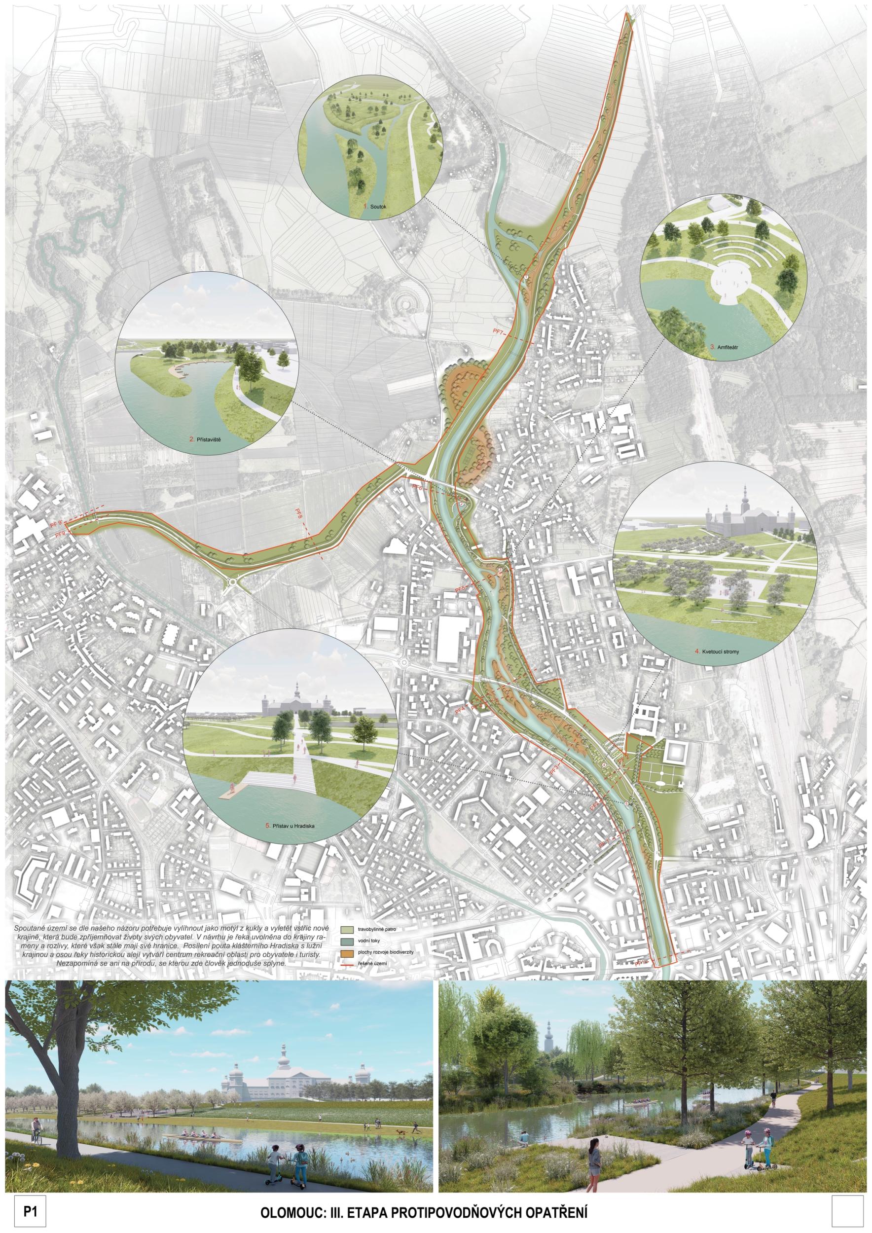
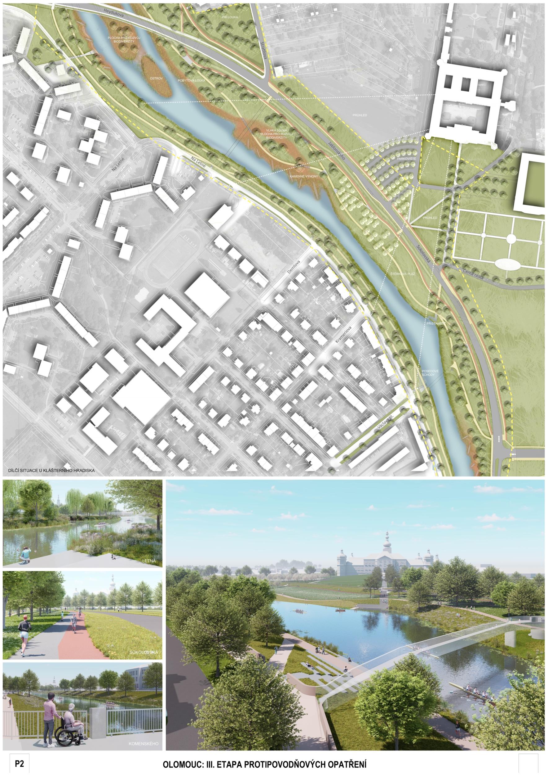
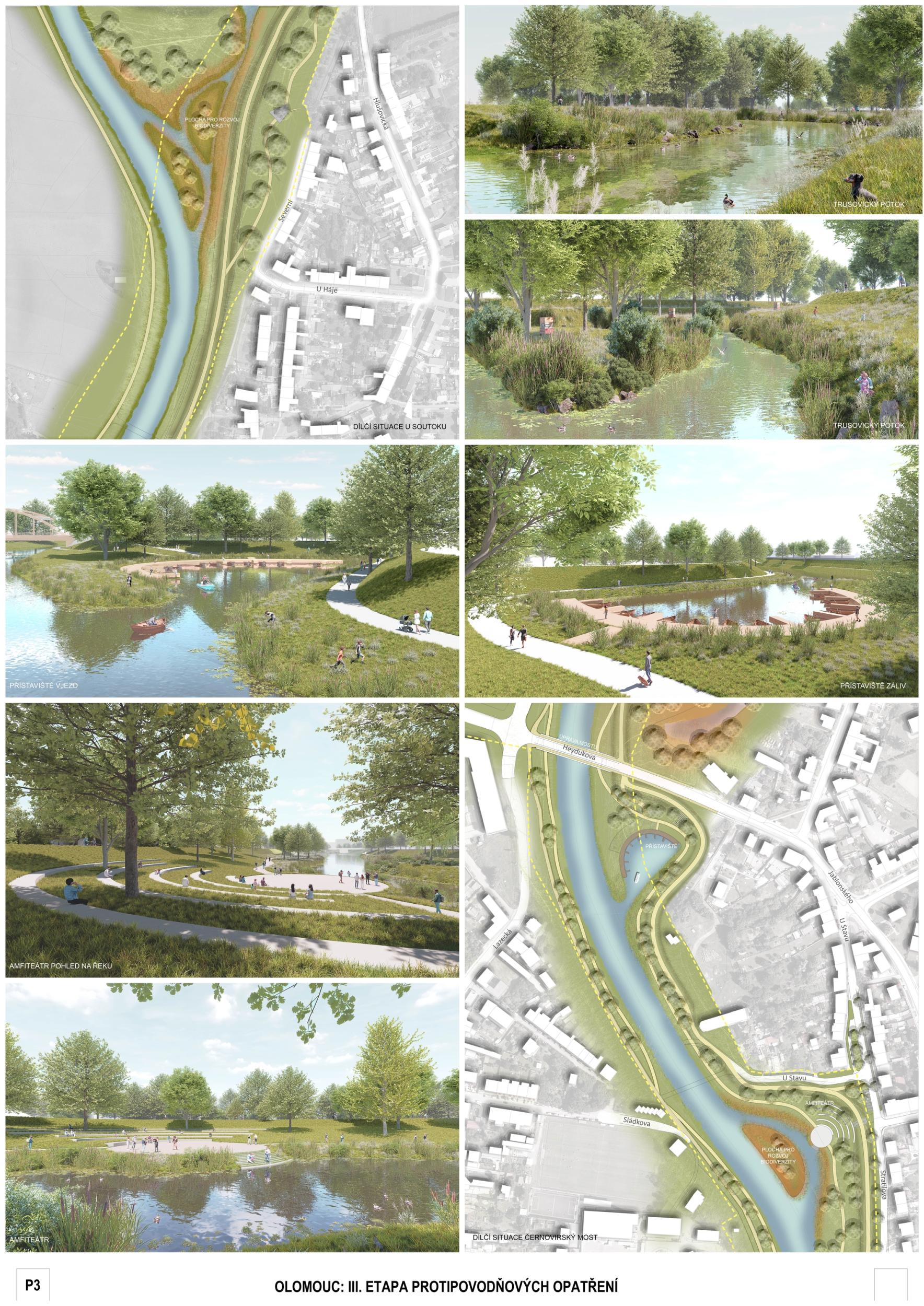
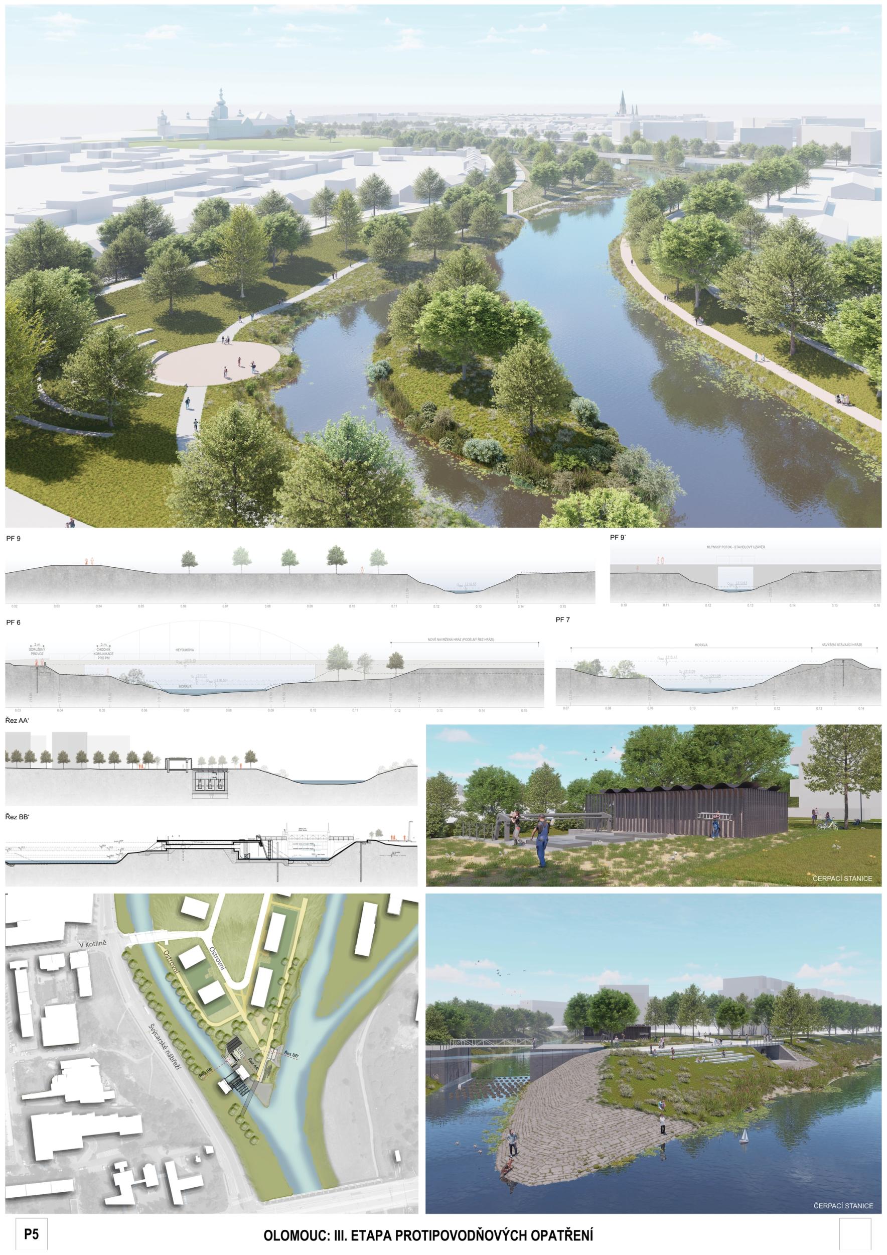
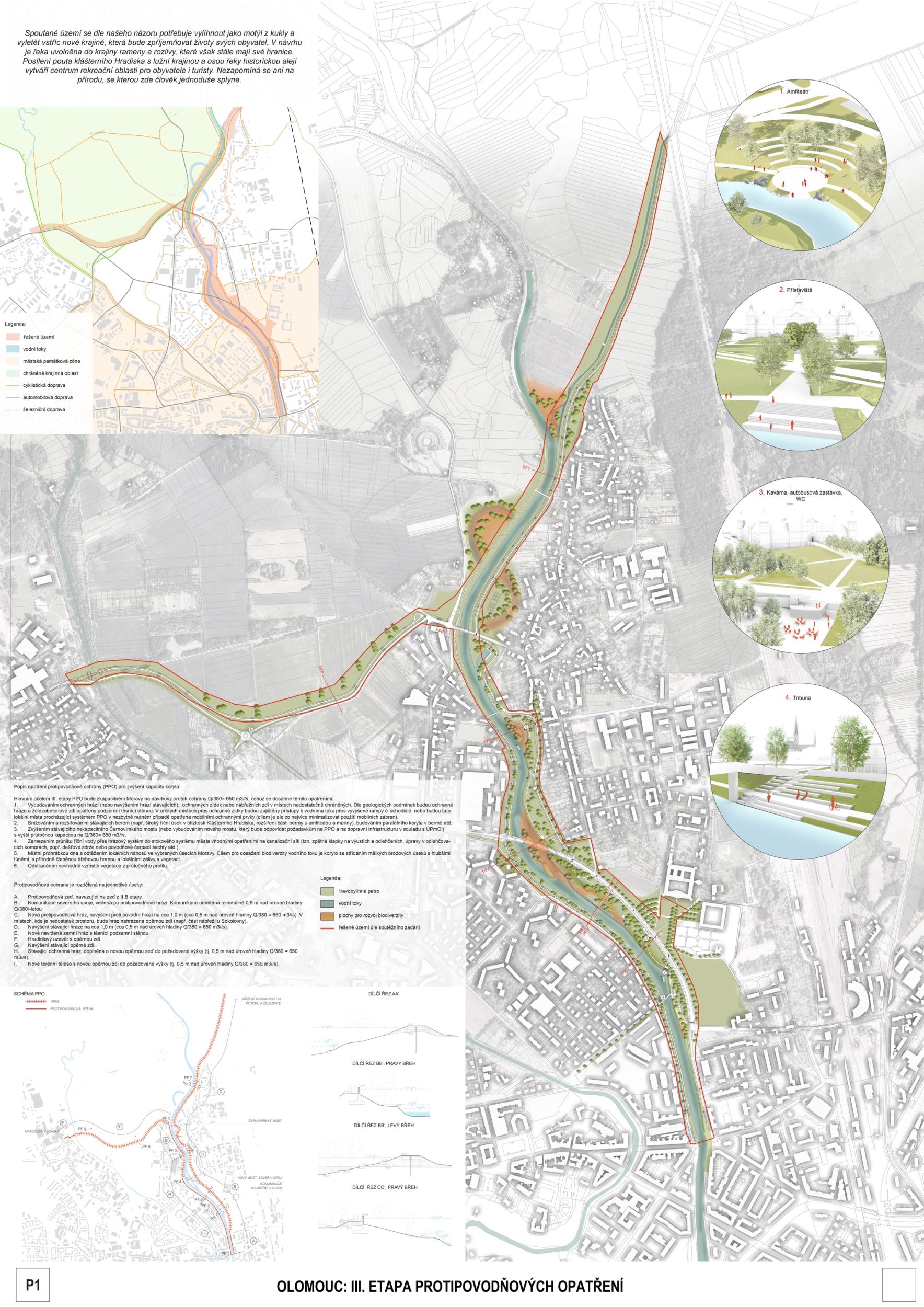
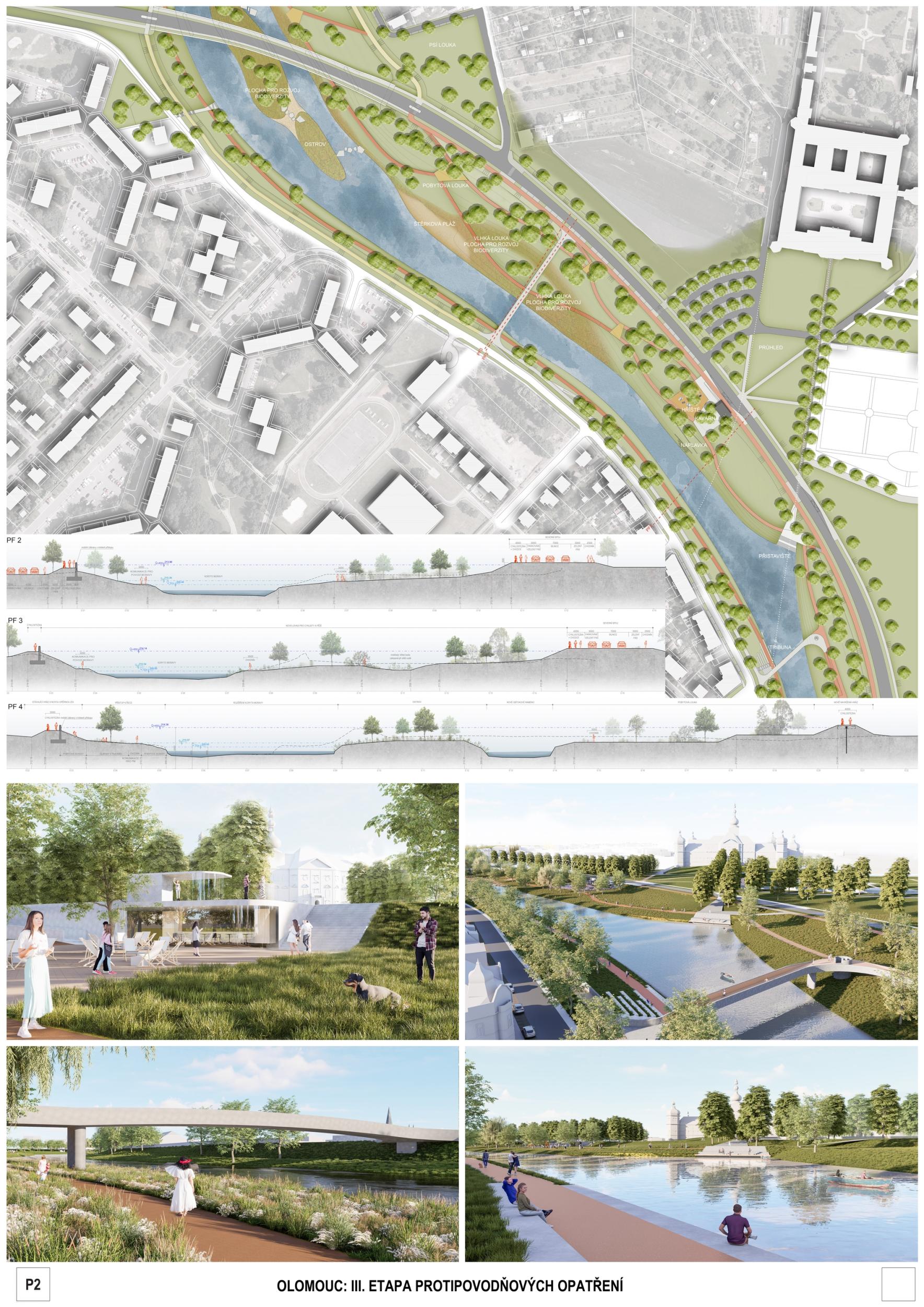
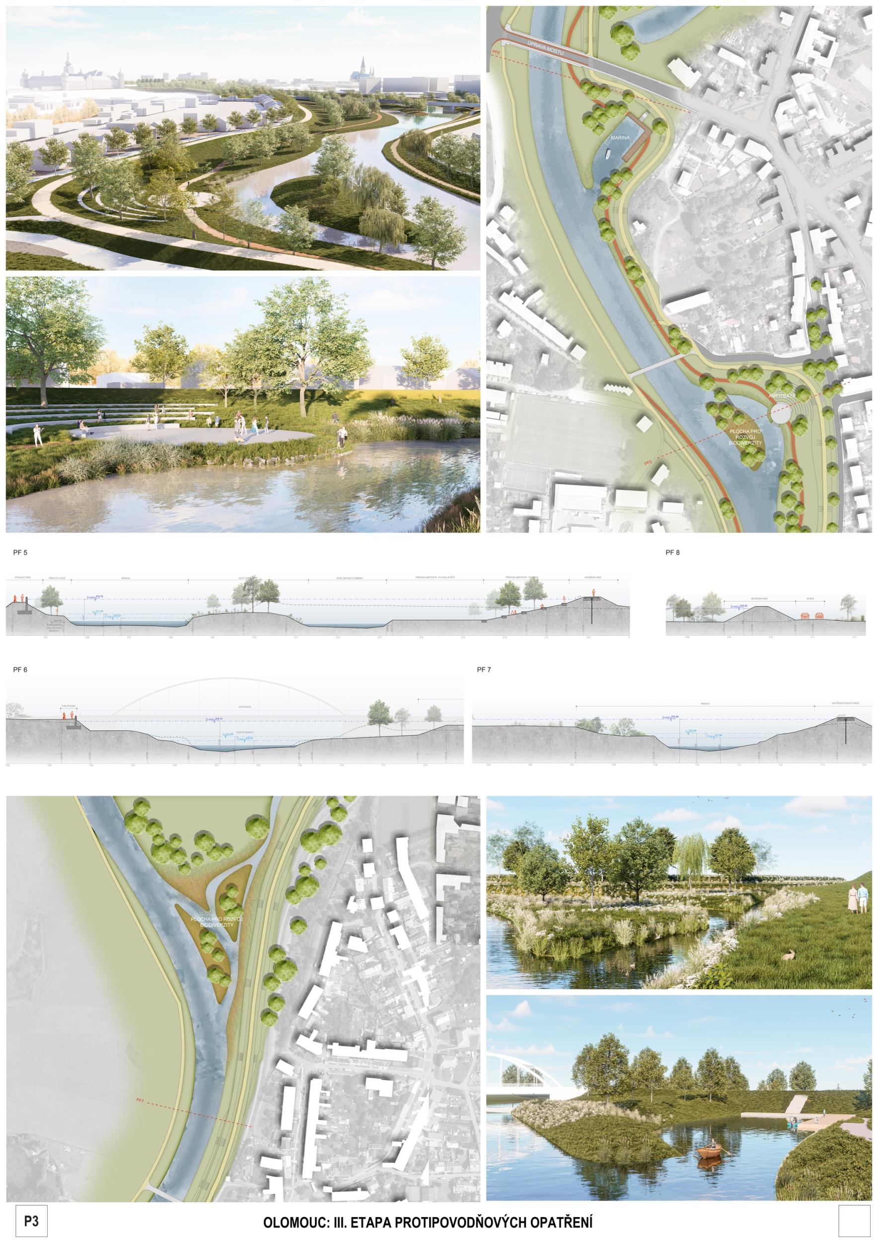
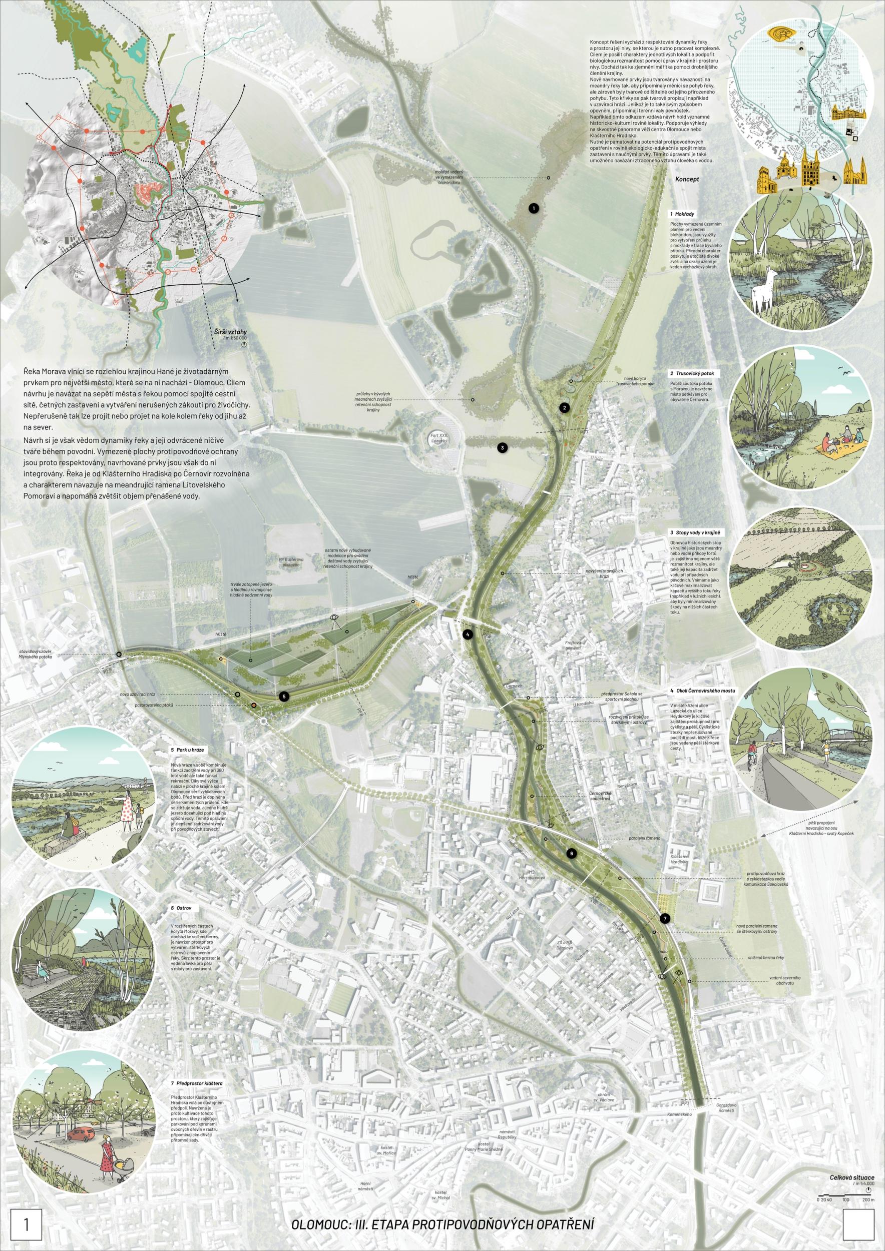
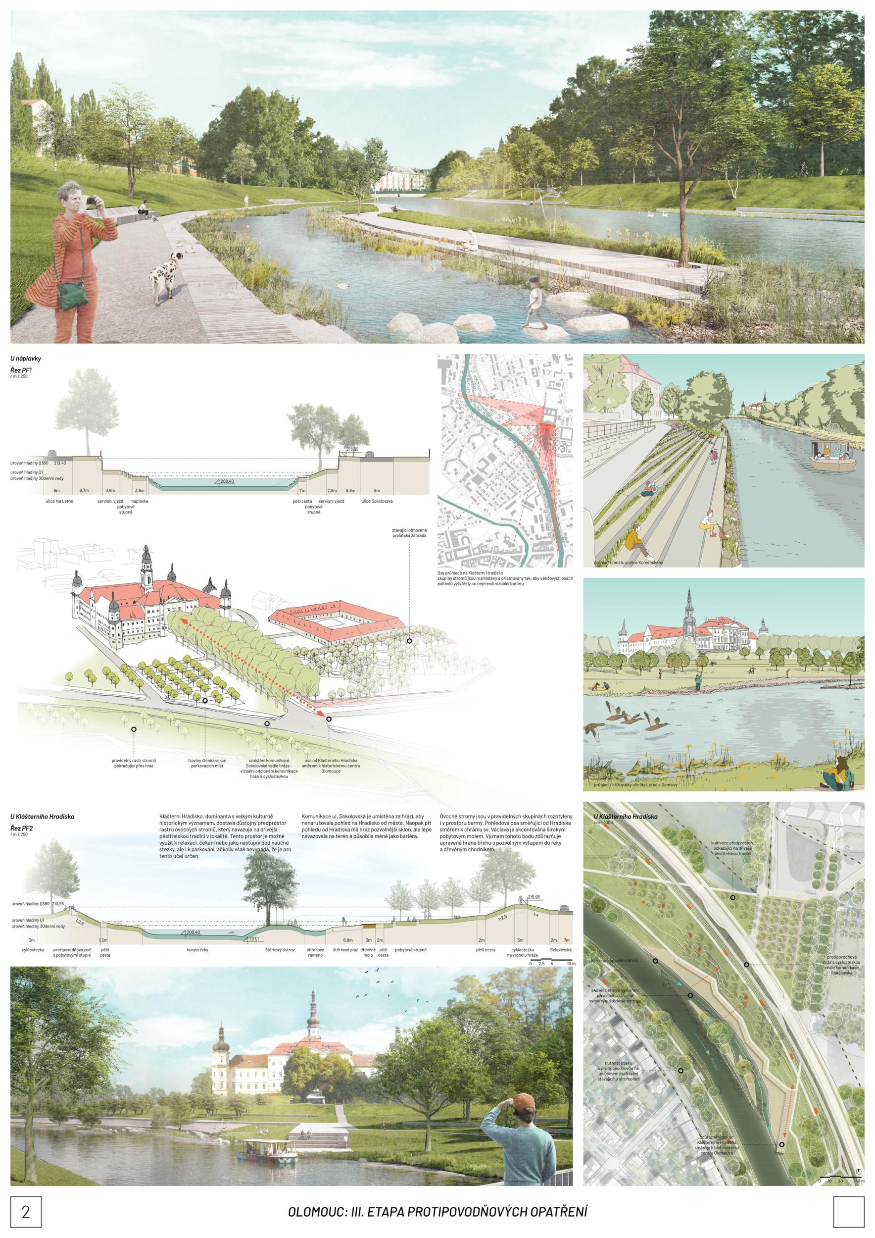
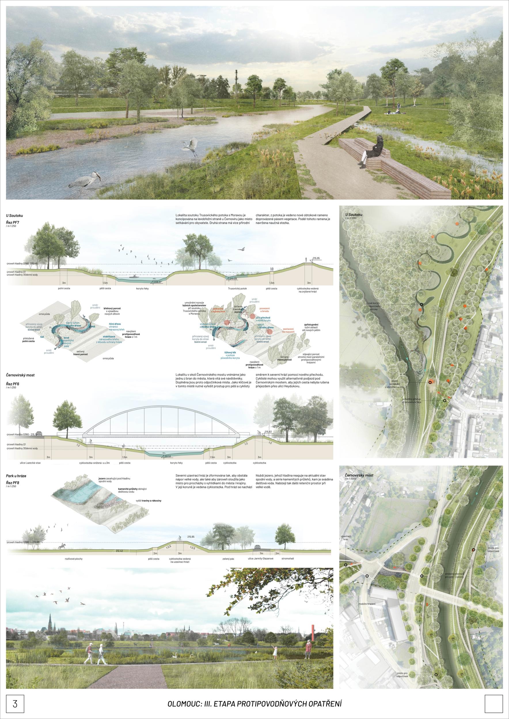
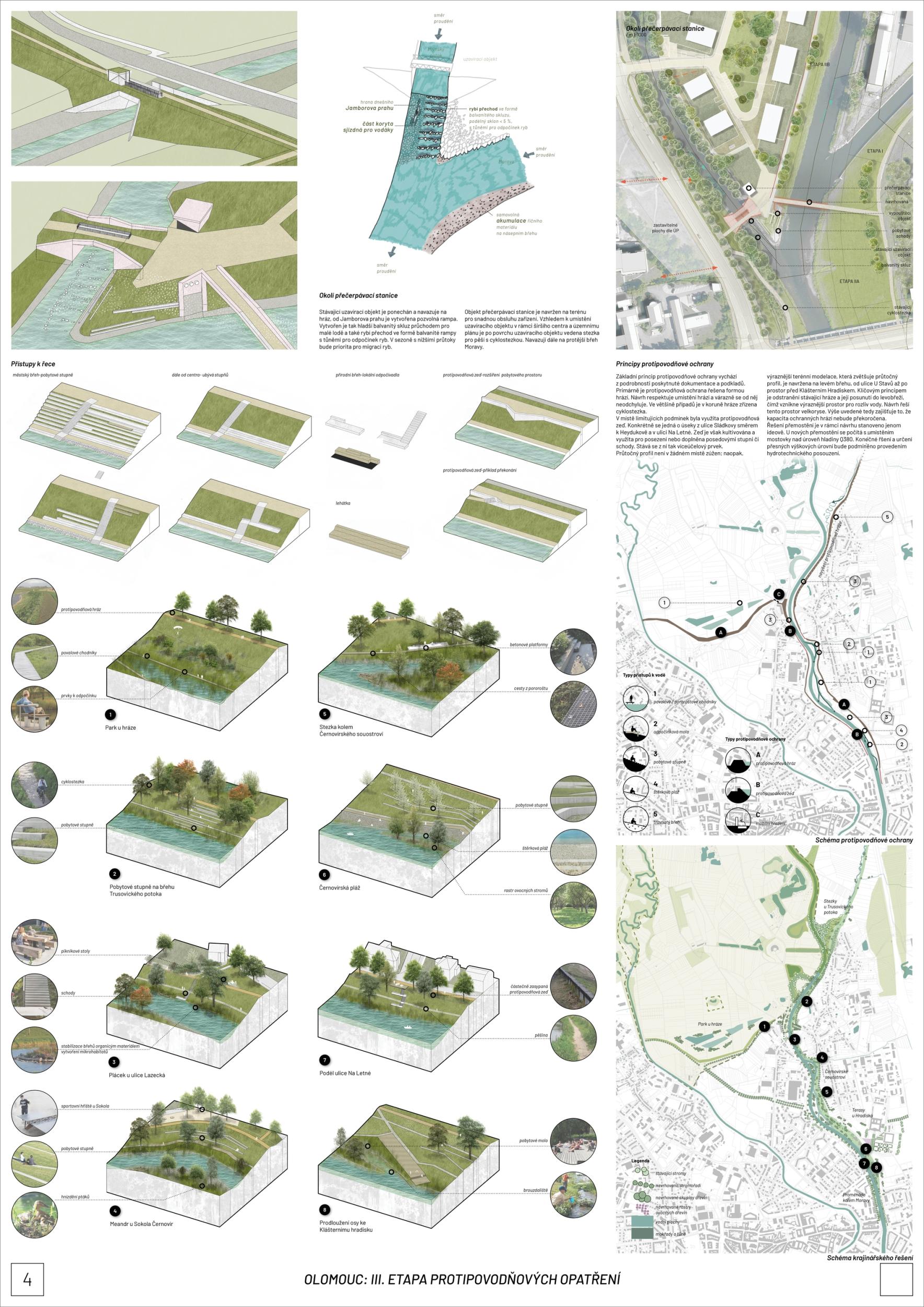
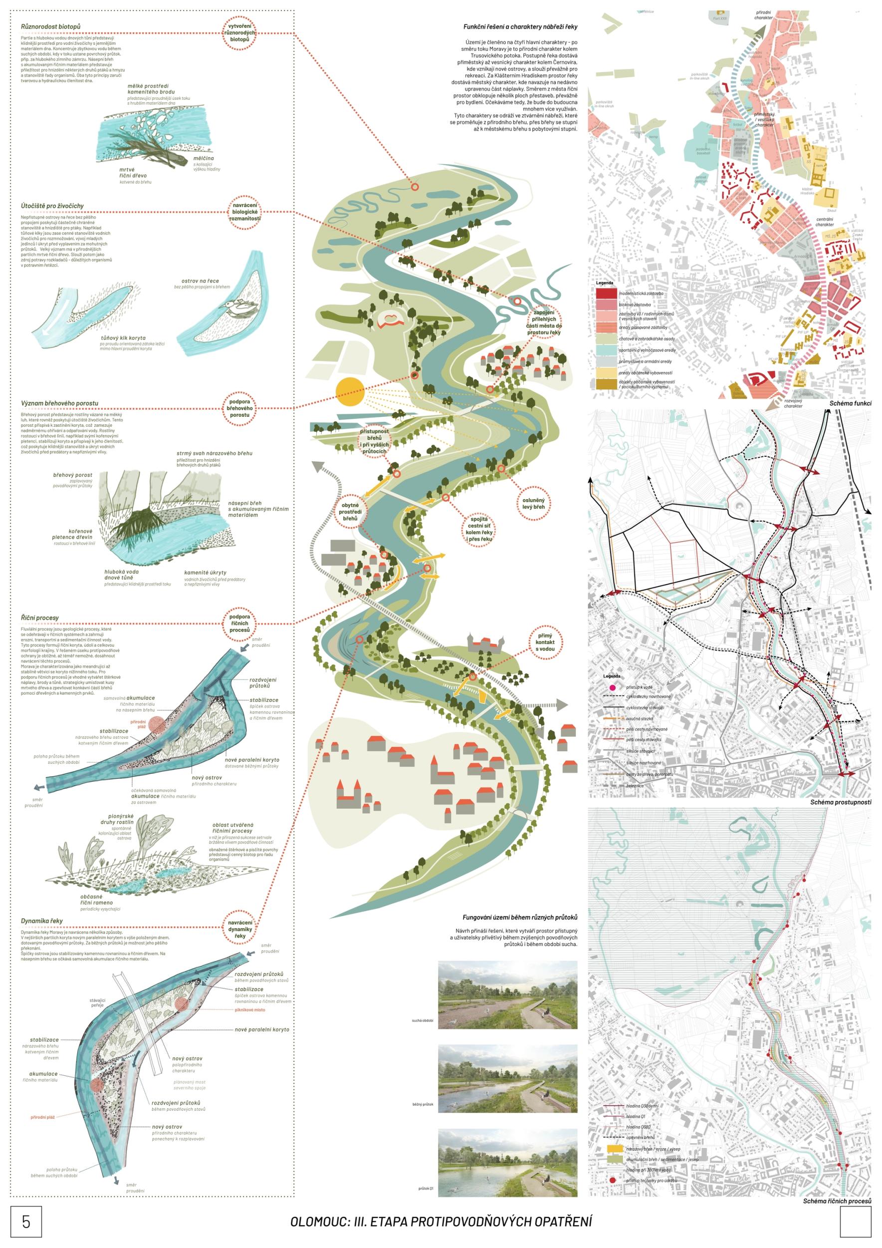
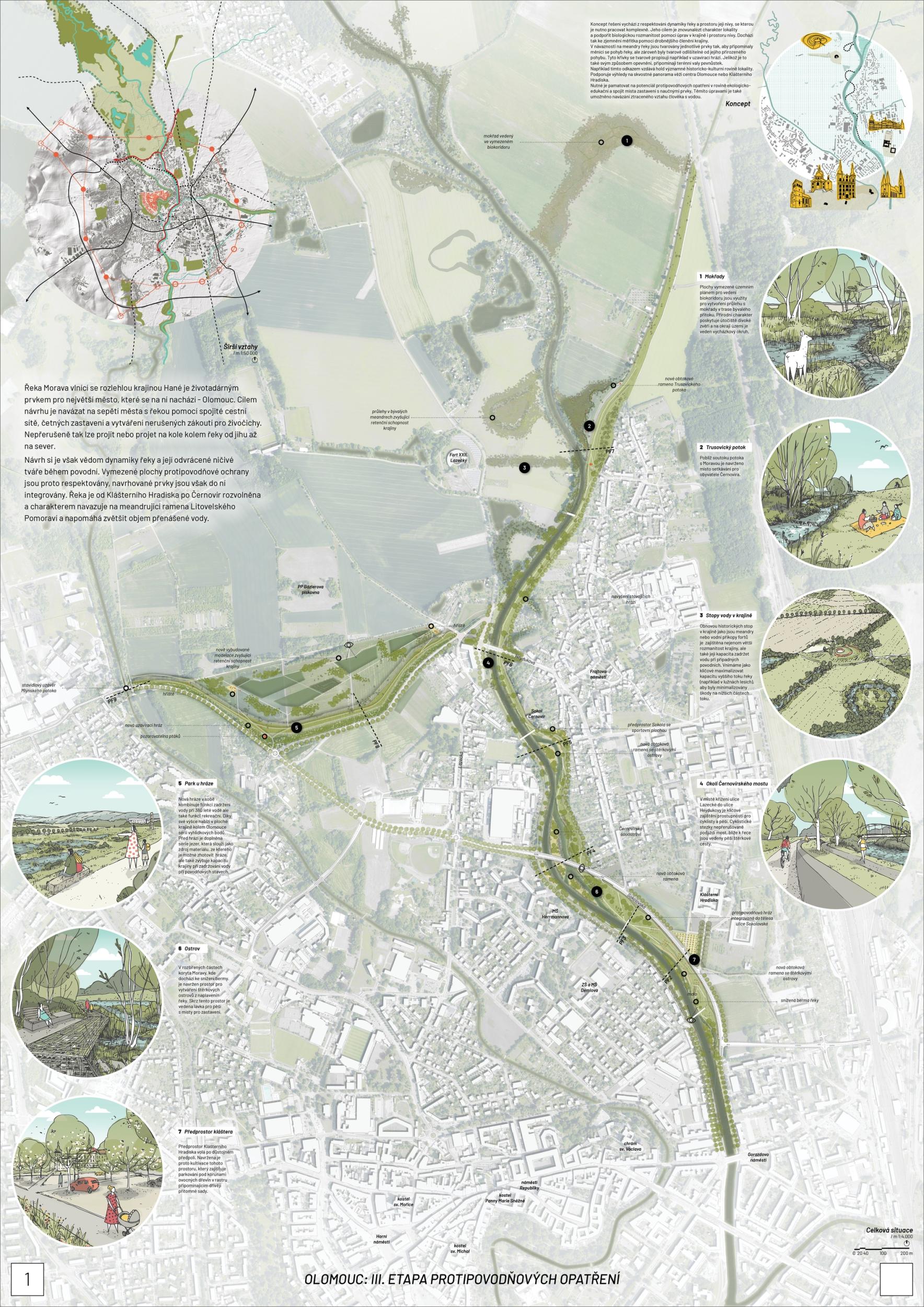
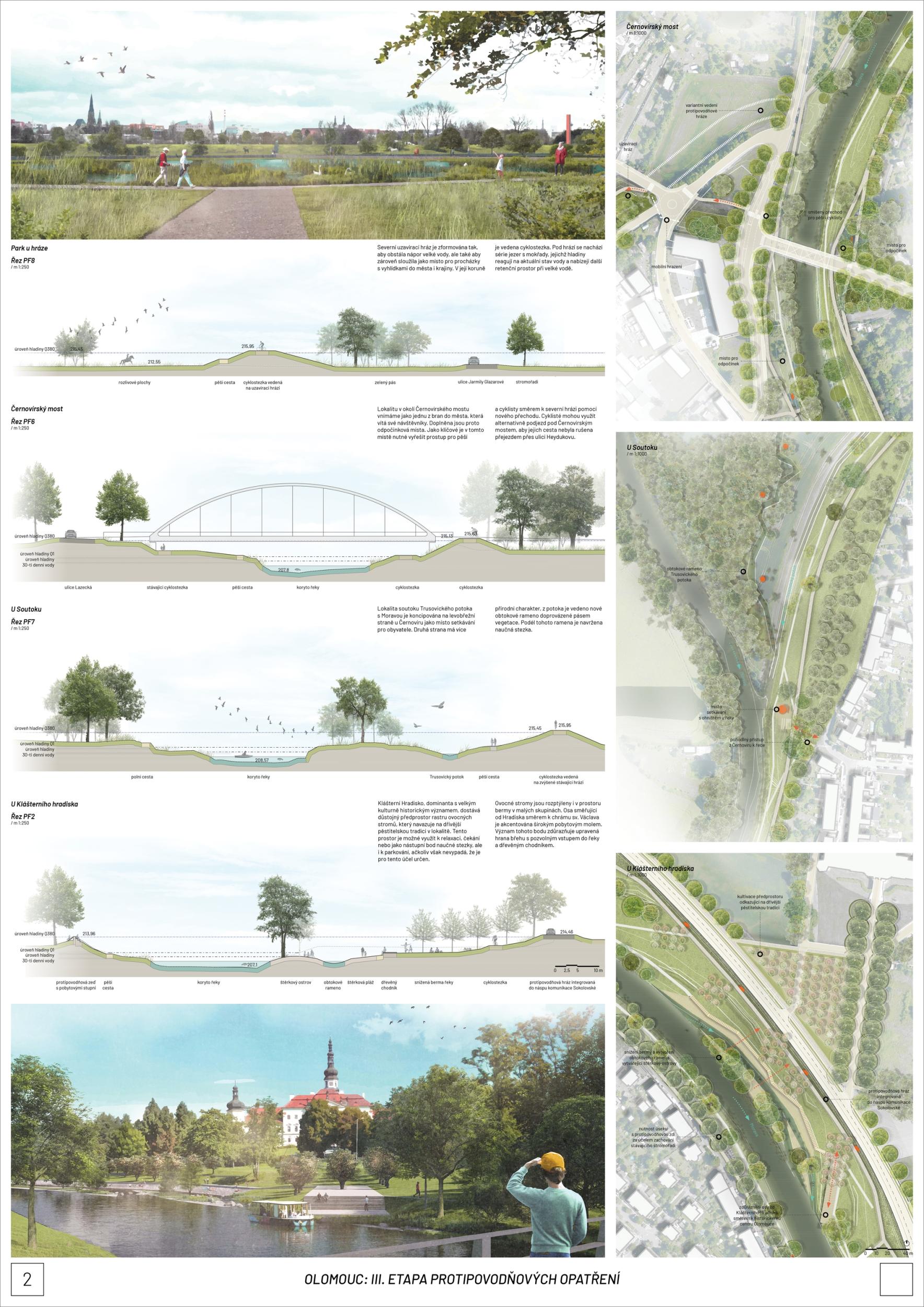
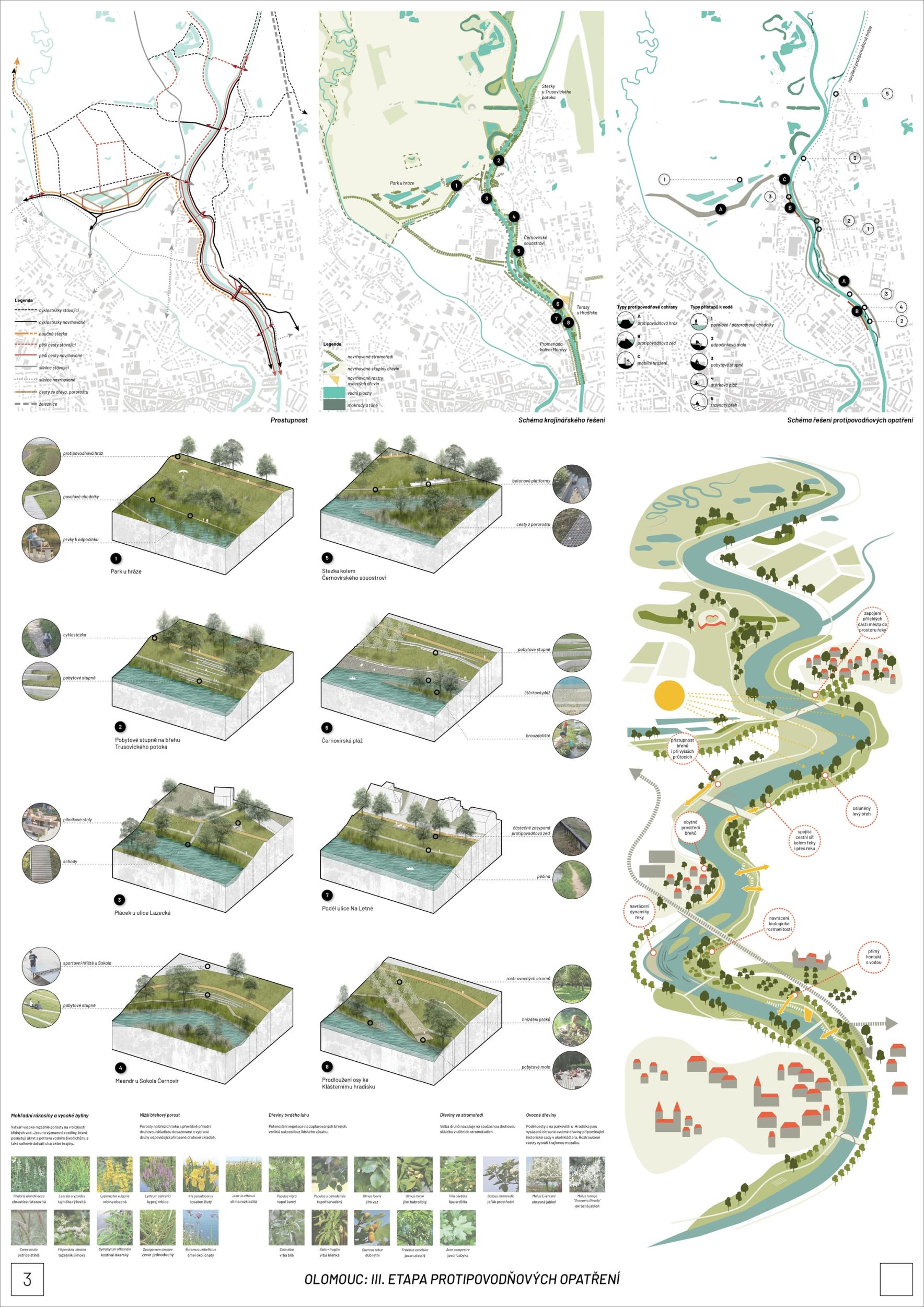
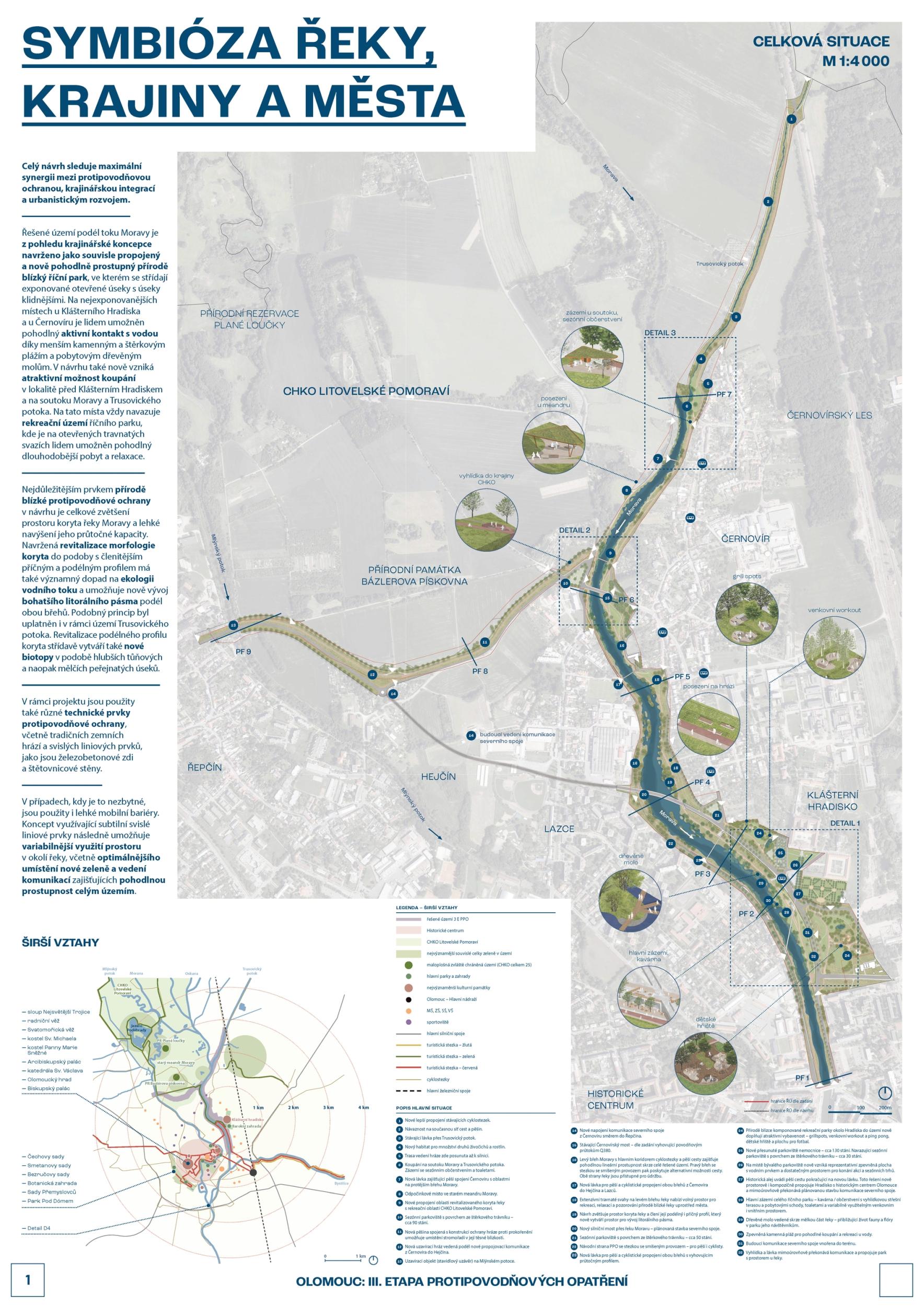
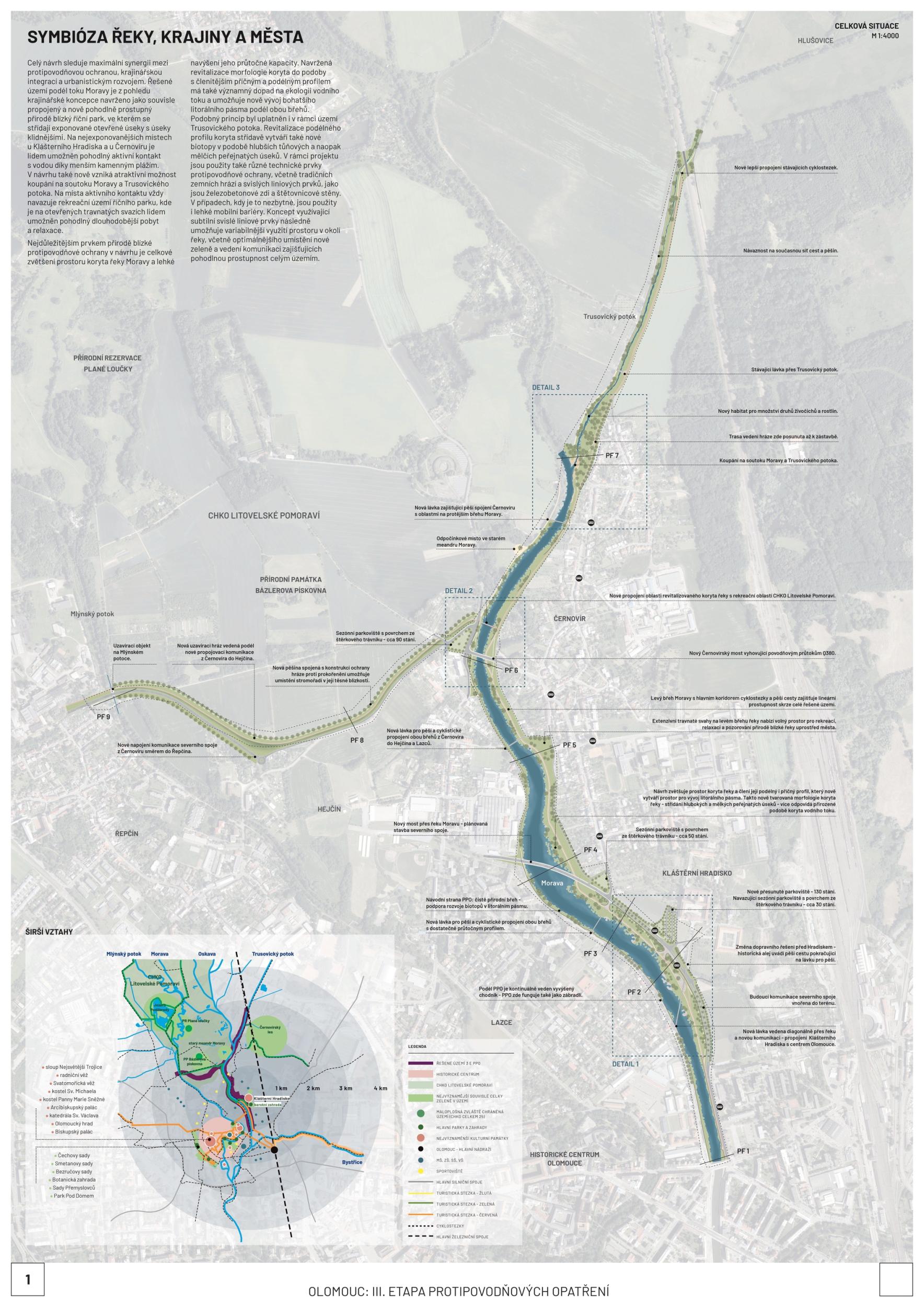
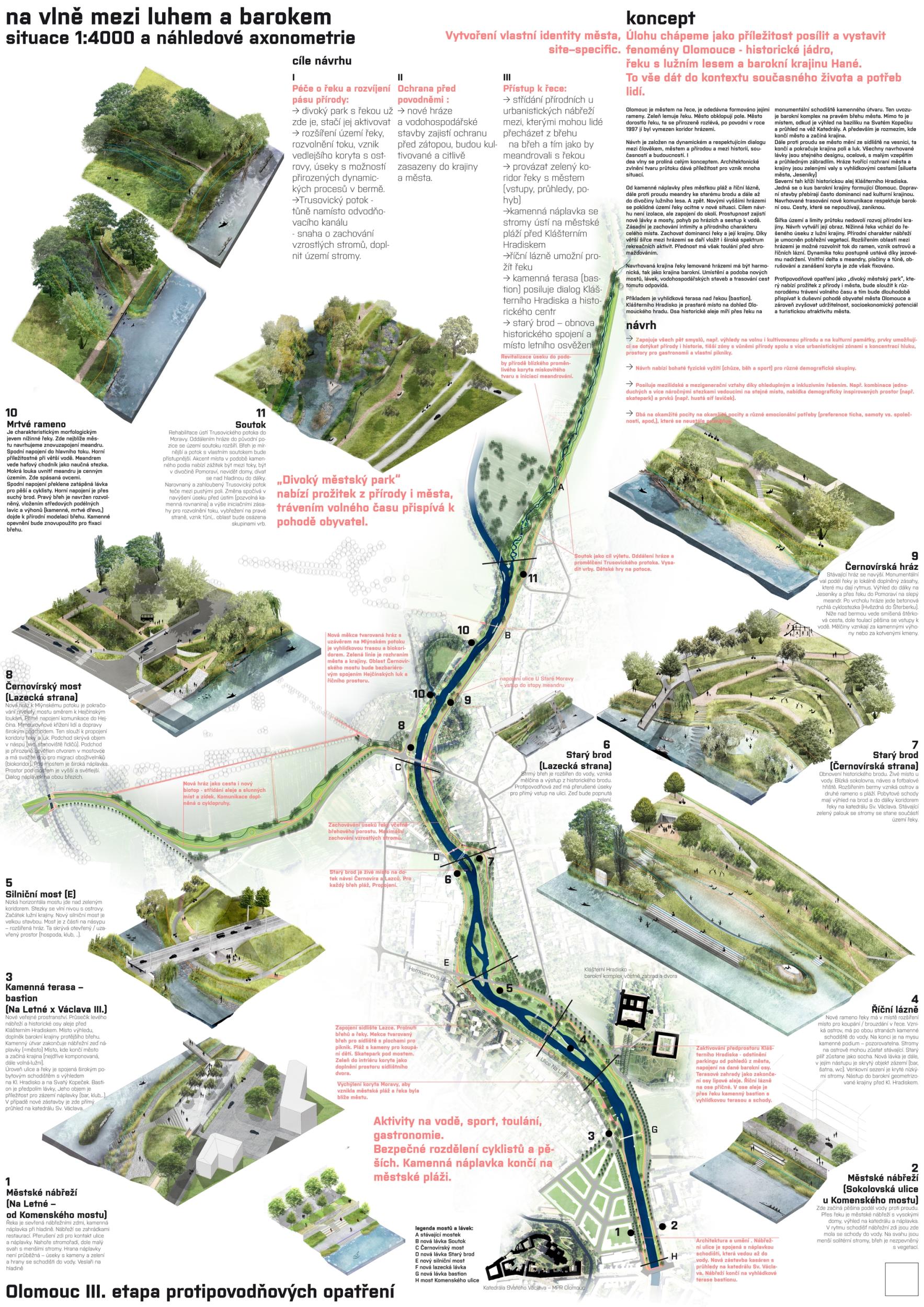
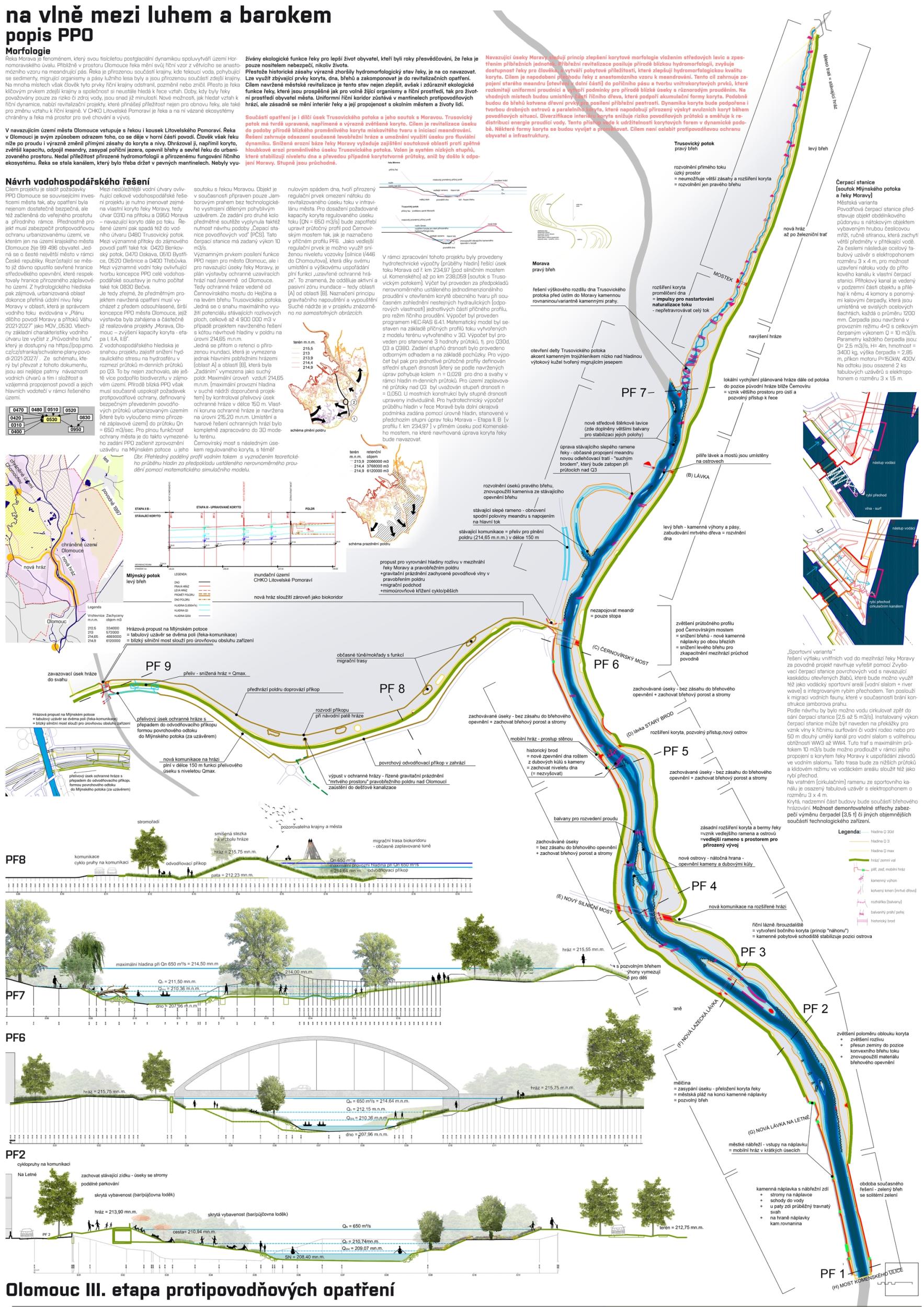
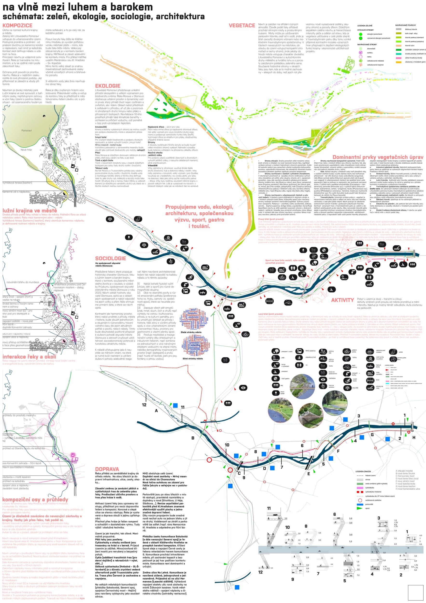
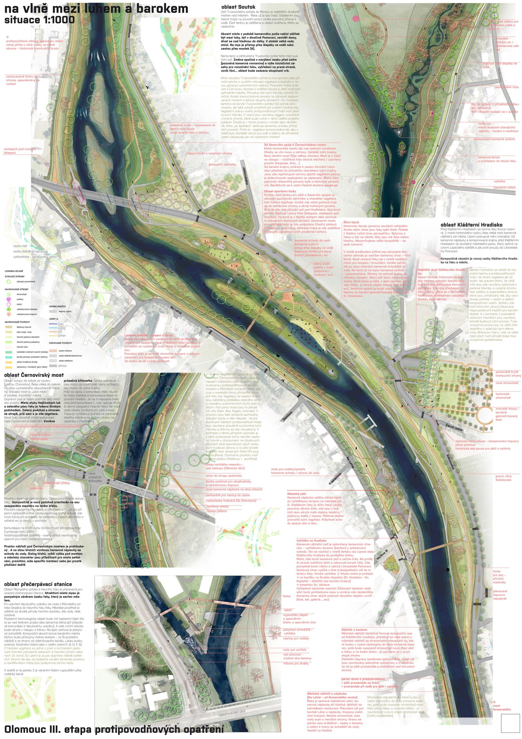
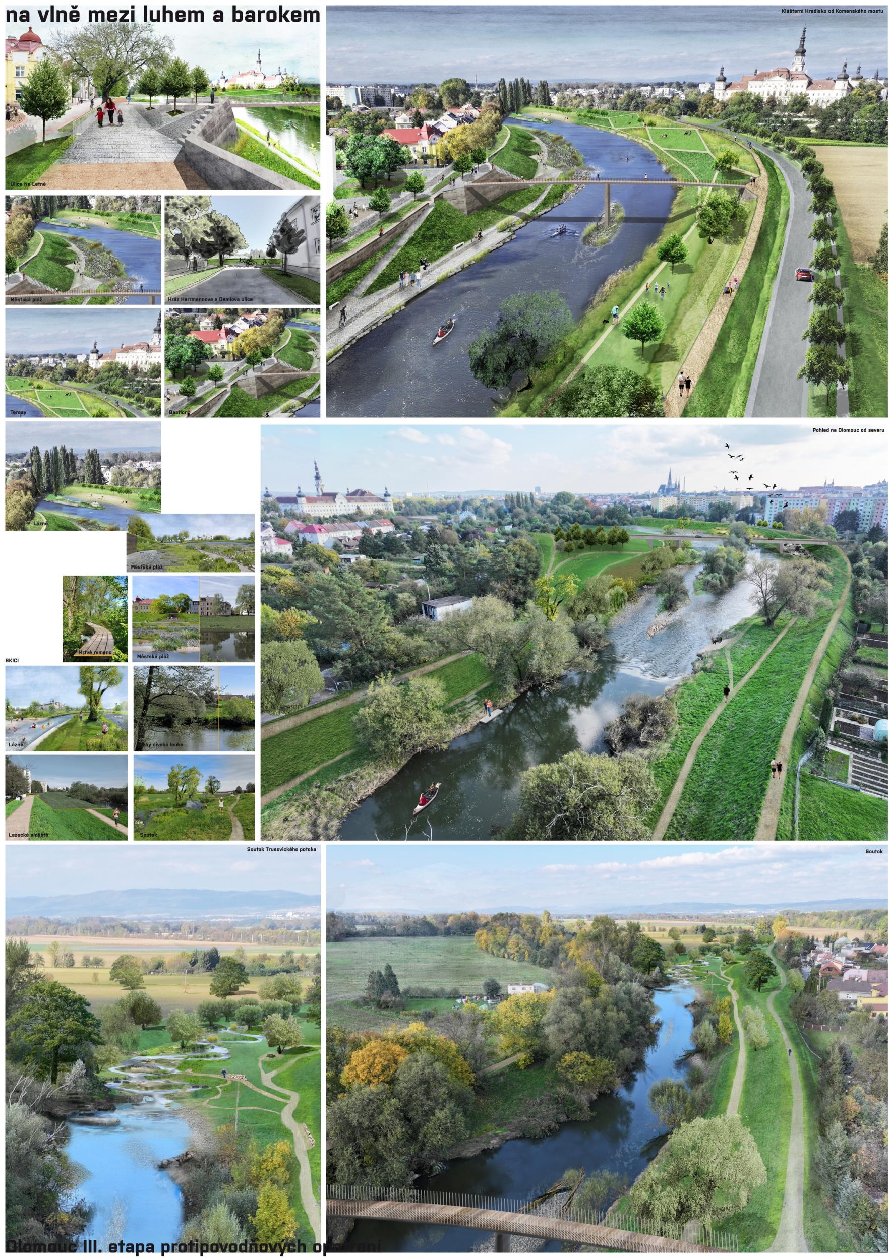
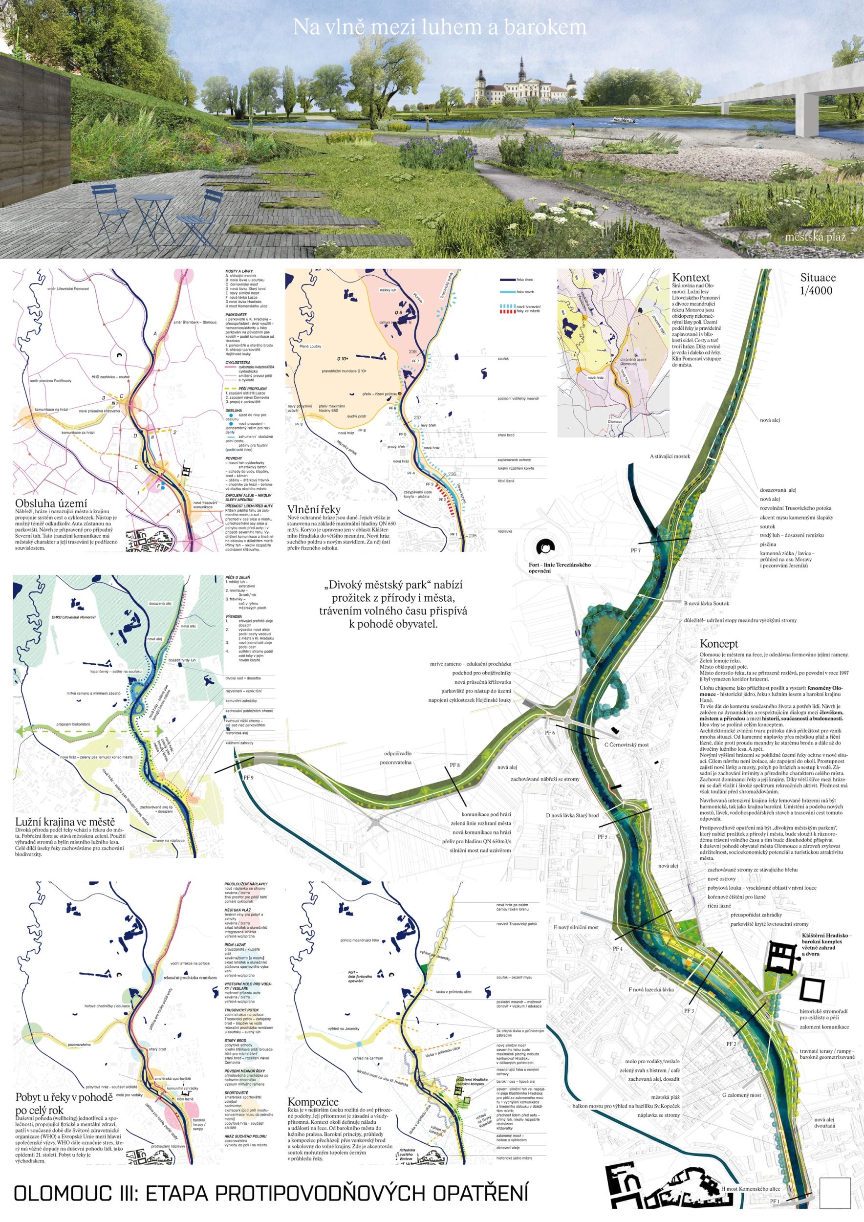
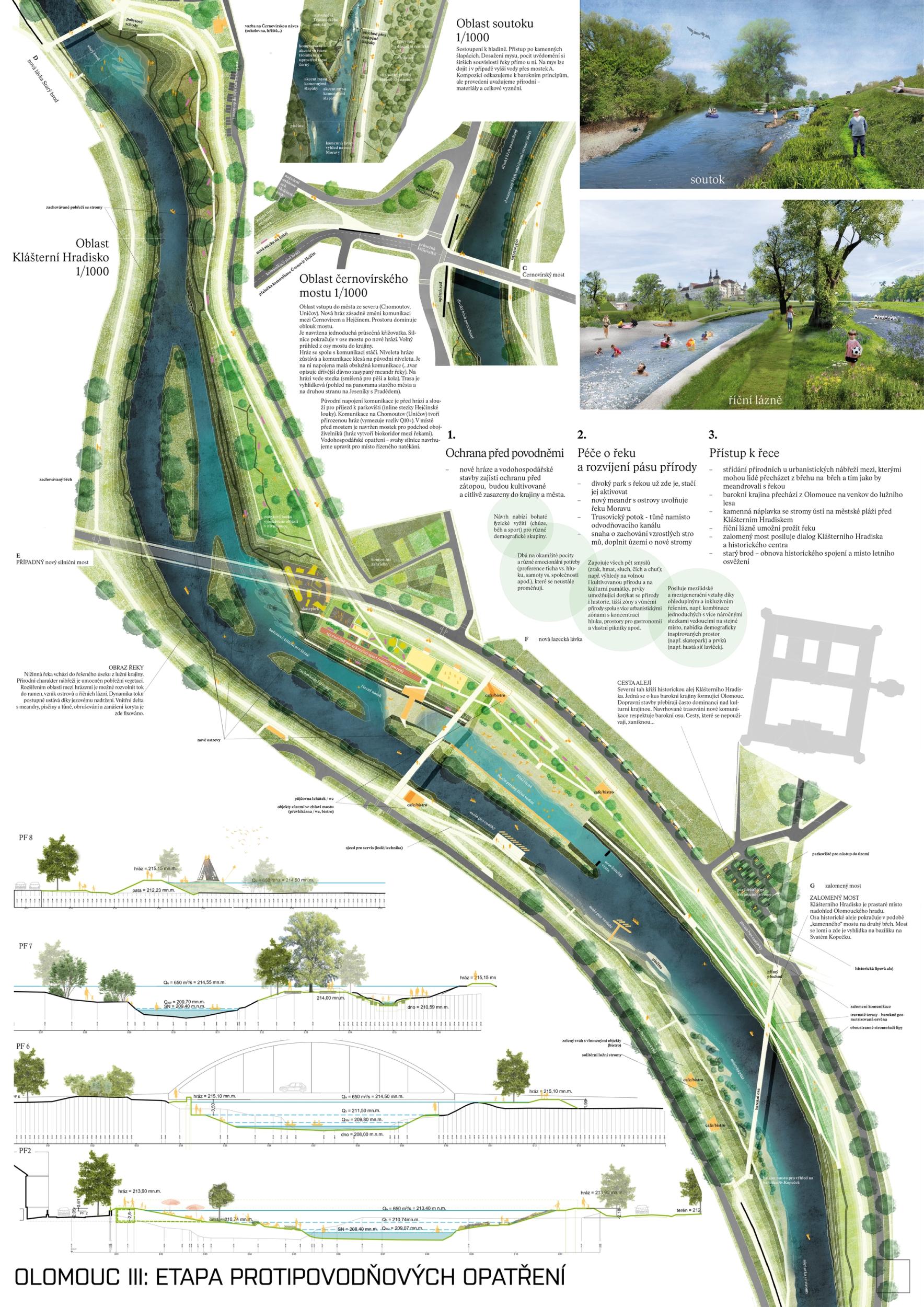
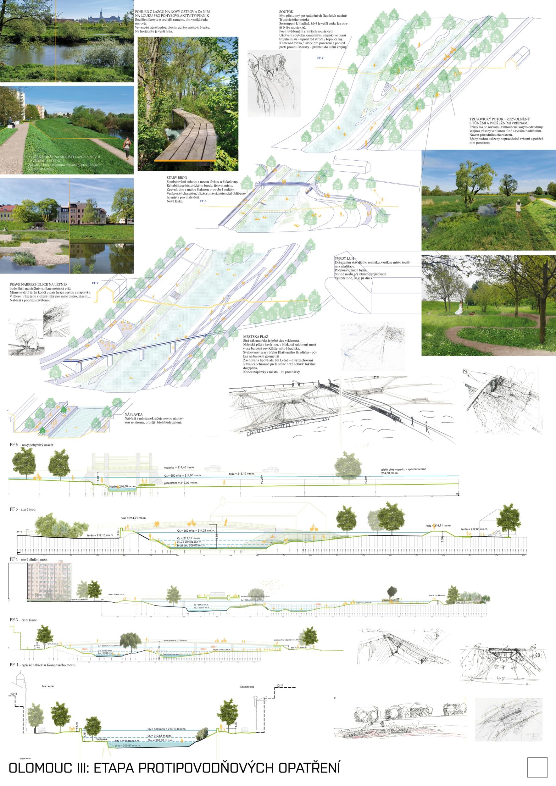
We see fortitude as resilience in the changing landscape and the city's structure and history. Conservation is an opportunity for its development. The variability of Moravia reflects the diversity of the river floodplain, the mosaic of historic traces of unique habitats and recreational landscapes. The Morava and its streams form symbolic axes of the landscape wedge of Litovel Pomoravie. The protection of Olomouc together creates landscape circuits, park axes, and the main public spaces around the Morava and the Mill Stream, which have a variable character according to the landscape circuits.

Jury Evaluation

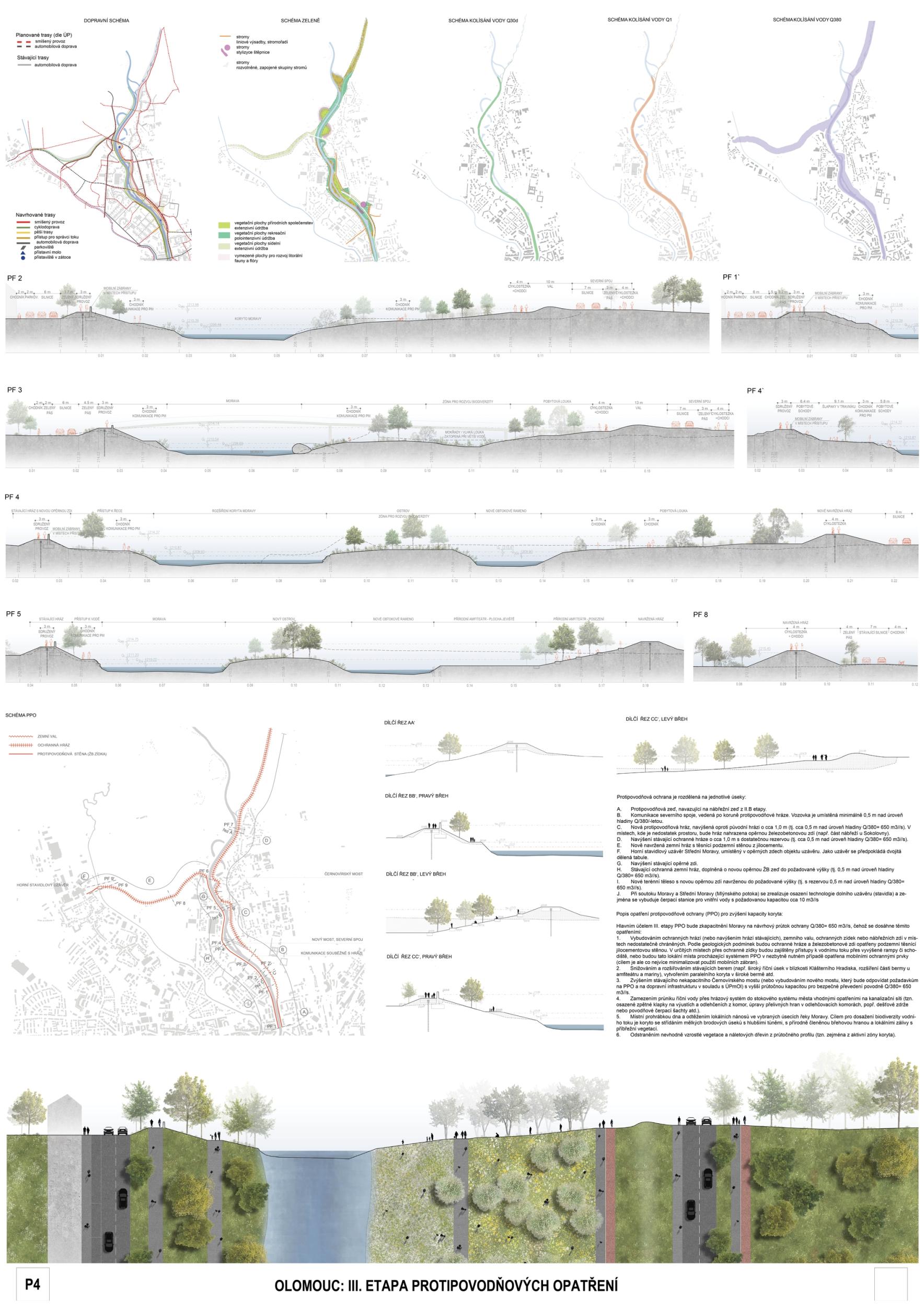
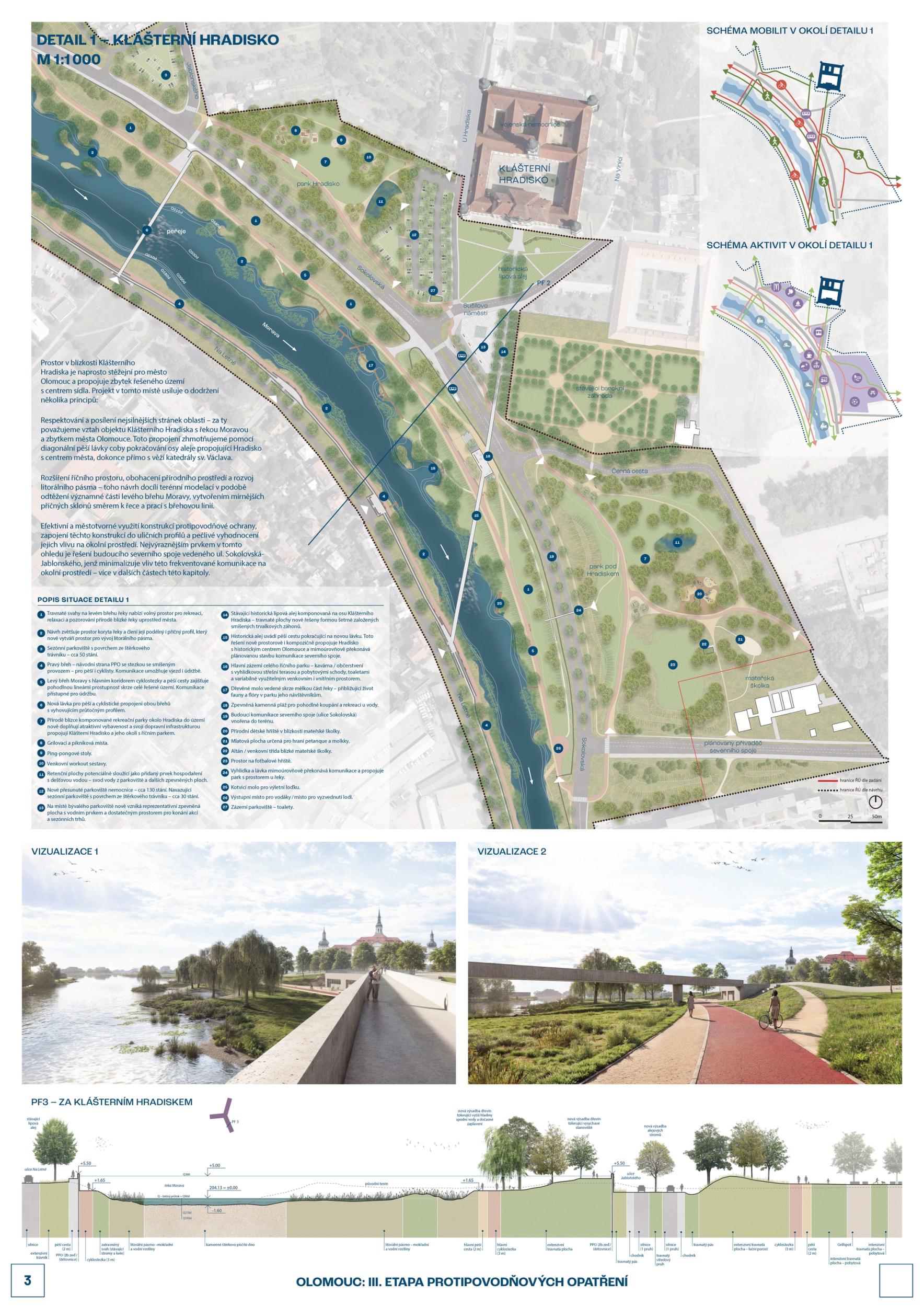
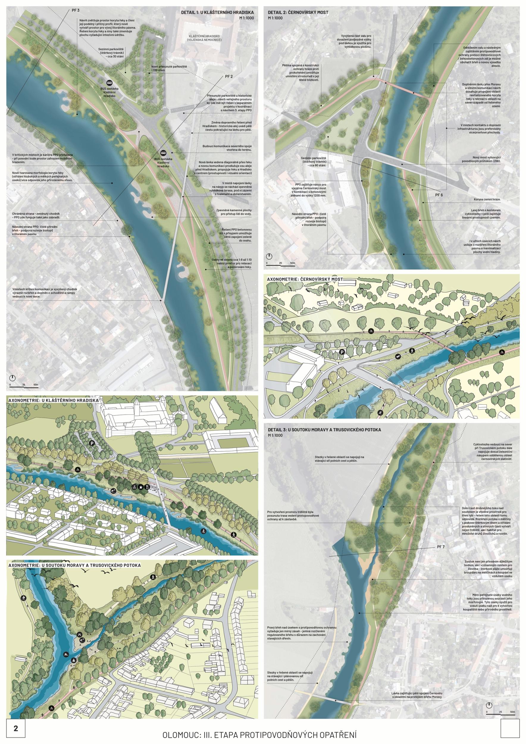
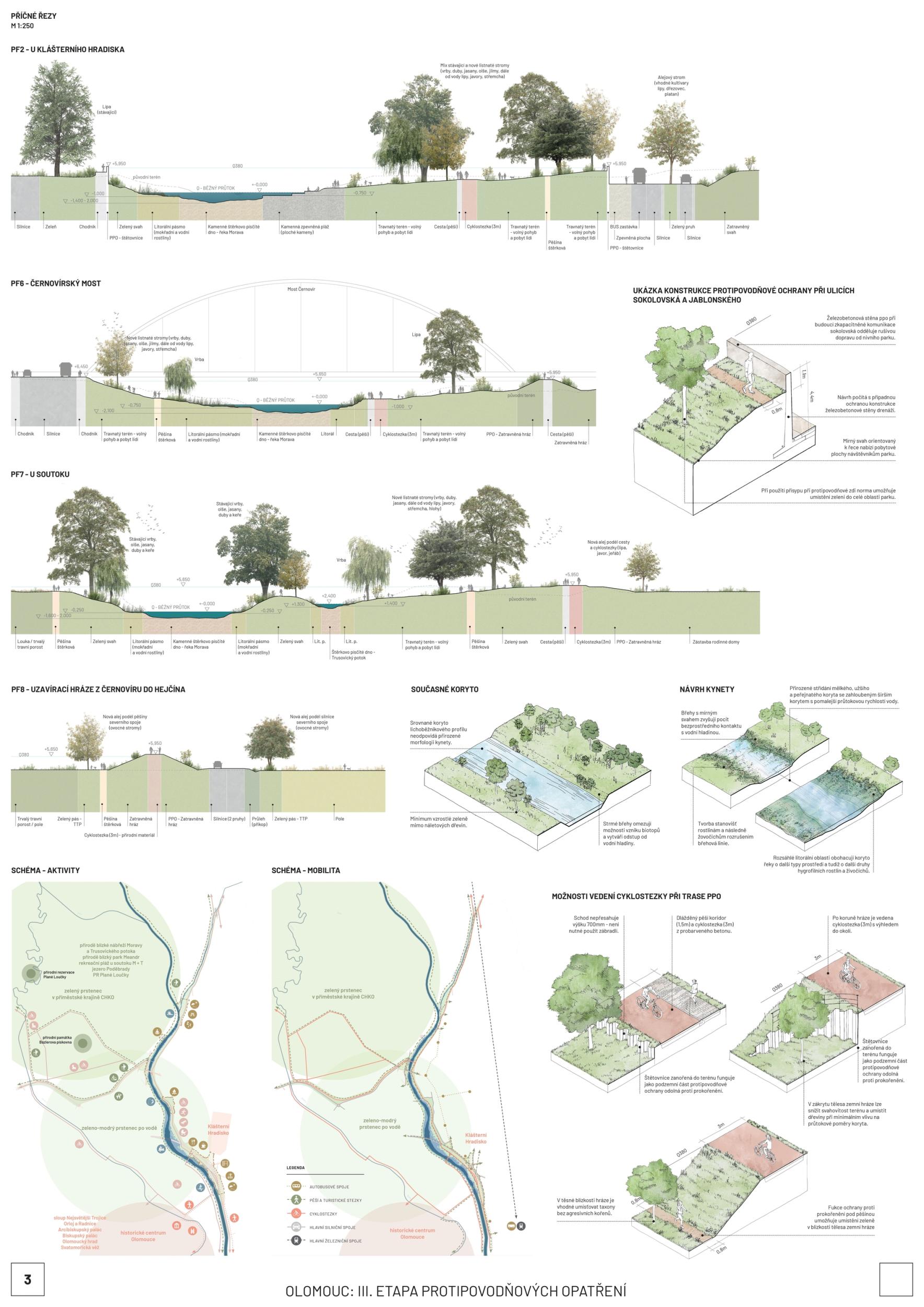
The first prize-winning design impressed the jury with its broad conceptual grasp of the area and its interconnectedness with the wider surroundings. It convincingly defines the centre, its relationship to the city, and its connection to other urban and natural structures. Its strength is also its argumentative base, which provides a solid basis for future implementation. The detailed phasing of the proposal allows for its gradual implementation and advocates wider intervention beyond the study area. From a functional point of view, the proposal is well thought out, although some elements are controversial. The transport solution is ambitious and works with a horizon of more than 50 years, but this will have to be adapted to the current conditions; the transport proposal does not correspond to the current master plan. With a more conservative approach to transportation, the proposal appears to be the clear favorite. However, slowing down through town and not limiting highway throughput may also be perceived as a disadvantage in terms of functional efficiency. From a compositional point of view, there is an apparent attempt to reinterpret the Baroque structure, particularly in the routing of the roads and the figure of the crossing of the avenues and tree lines below the Castle. This solution may seem incomprehensible and does not fully correspond to contemporary urban planning principles. Still, at the same time, it has the potential to support the logic of the traffic design. The proposal shows some reserves that can be used with different scales and characters of the territory. The transition between the natural and urban environment is handled relatively homogeneously in the proposal, leading to a lack of nuance between the different parts; the urban contact is not considered. The concept of biodiversity is questionable in some places - in specific locations, it appears to be an artificially implanted element without sufficient logic. One of the most significant risks of the proposal is its design in the most critical location - the response to flood risk is not yet sufficiently thought out. Positioning the main elements perpendicular to the flood can be problematic. However, the redesign may also lead to savings and a better logical layout. Another critical point is the conceptual and hydraulic non-functionality of the solution in the area in front of Hradisko - especially concerning the biodiversity island, whose location on the opposite bank would make more sense. The amphitheater's location in the biodiversity development area is also a question. In spite of these reservations, the proposal remains the best developed solution overall. Its high level of detail and elaboration makes it a convincing basis for the area's future development.

Previous Next
2nd Prize
  • Author P.P. Architects - PRIS
  • Team Pavel Pekár, Kseniia Zharova, Marek Holán, Bořek Knytl, Olga Lučinová, Kamila Dohnalová, Martin Řehulka, Simona Kubišová, Anna Divilová, Laura Boarová, Pavla Nováková, Adam Šimíček
  • Brno
Annotation

In our opinion, the shackled territory needs to emerge like a butterfly from its chrysalis and fly out to meet a new landscape that will make the lives of its inhabitants more pleasant. In the proposal, the river is released into the landscape by the arms and spillways, but these still have their limits. Reinforcing the bond of the Monastic Keep with the floodplain and the axis of the river through the historic avenue creates a recreational hub for residents and tourists. Nature is not forgotten either, with which one simply blends in.

Jury Evaluation

The design, which won the second prize, shows a moderate and rational approach to the area's solution. Among its greatest strengths is the work with the alignment of the Morava River and the use of its potential to protect the development from flooding. Although the design appears austere at first glance, it meets the requirements for a nature-friendly intervention solution in combination with an appropriate river morphology. One of the design's main benefits is its ability to use the area for natural flood dispersal without excessively using concrete elements. The solution avoids unnecessary revitalisation interventions and emphasises the maximum use of natural features. This approach promotes the site's natural character and also minimises damage during flood passage. In a recreational context, the proposal functions primarily as a park area. Different opportunities for movement along the river are proposed - the paths on each bank are designed differently, allowing them to be targeted differently for pedestrians or cyclists. The river's potential as a public space is exploited in several morphologically adapted places, for example, in extensions or islands. The moderate programme in the river corridor makes it relatively easy to restore after a flood, at low cost and in a relatively short time. However, the proposal suffers from some weaknesses. Despite the extensive graphic representation in the form of visualisations of the area, the legibility of its ideas and intentions is difficult. Unfortunately, the lack of clarity of the overall concept and some of its detailed parts leaves many aspects open to interpretation. The proposed solution's approach is relatively mechanical—in some parts, it looks more like a cut-out corridor with no urban continuity with the surrounding sites and the city. The choice of the location of individual active elements in the proposal (amphitheatre, workout zones, etc.) lacks logical justification in the wider context. Another problematic area is the wharf, whose function is desirable but which is oversized in terms of capacity and architectural design. The amphitheatre is similarly oversized, and its scale is not sensitive to the landscape. In terms of architectural means, the design works with appropriate principles, but the specific representation of these principles is not entirely convincing. Overall, it is a solid design whose main strengths are respect for the natural morphology of the river and a well thought out alignment that allows for recreational use. As a result, future operating costs are minimal. Weaknesses include its difficulty in legibility, its mechanical approach to design, the unbalanced scale and treatment of some elements, and the lack of connection with the surroundings. Despite these shortcomings, the proposal presents a solution with very appropriate flood protection measures and a sustainable approach to the area, which has the potential to contribute positively to the development of the riverine space in the city.

Previous Next
3rd Prize
  • Author Till Rehwaldt
  • Team Adéla Chmelová, Eliška Nováková, Eliška Buš, Radka Peška Matoušková, Garth Woolison, Jesep: Miroslava Plevková, Roman Pitka
  • Prague
Annotation

The Morava River, rippling through the vast landscape of Haná, is the lifeblood of the largest city on it—Olomouc. The design aims to link the town to the river through a continuous road network, numerous stops, and the creation of undisturbed corners for animals. In this way, walking or cycling uninterrupted around the river from south to north is possible. However, the design is aware of the river's dynamics and its inverse destructive face during floods. The designated flood protection areas are therefore respected, but the proposed elements are integrated into them. The river is loosened from Klášterní Hradisko to Černovír and is linked in character to the meandering arms of Litovelské Pomoraví, helping to increase the volume of water transported.

Jury Evaluation

The third prize-winning design introduces a new theme - a park above the dam, representing an interesting concept with the potential to enrich the area with a new landscape element. The use of blind arms and the search for the dynamics of the river should be highlighted positively. The diagrams and explanations of the design describe its principles quite clearly. Still, these intentions are not always sufficiently legible in the drawings, which can complicate their implementation and understanding of the overall design. A weaker design aspect is the landscape component, which appears insufficiently well thought out. In particular, the choice of fruit trees is not appropriate for the conditions and does not support the overall concept of the area. Furthermore, the proposal raises problems with the bypass, which is perceived as a territorial limit, but its solution remains undeveloped. In addition, the river bed is narrowed in several places, which is inappropriate and dysfunctional regarding flow. There is also a lack of detailed interconnection between the different components in the design, which results in some sub-elements, such as the bridge and the levee line, not being linked in a sufficiently functional or compositional way. This deficiency weakens the proposal's overall coherence and its ability to fit harmoniously into the broader context of the area. There is also a lack of hierarchy of spaces in relation to the city and justification for some of the linkages. Overall, the proposal presents interesting ideas (e.g. the organic shapes of the landscape are reflected in the design of some of the buildings as an interesting aesthetic element). Still, its implementation would require more elaboration, especially in the landscape aspects and the detailing of key components. Despite these shortcomings, the concept of the park above the dike is supportive and offers potential for further development of the area.

Previous Next
Finalist
  • Author Sweco+A8000
  • Team Pavel Kvintus, Martin Sedmák, Martin Krupauer, Ruby Pavoučková, Jan Procházka, Martin Pavel, Radek Veselý, Libor Sychra, Adam Křenovský, Ondřej Slavík - ichtilogy
  • Prague
Annotation

The proposal combines flood protection, landscape integration and urban development. The area along the Morava is transformed into a river park with exposed and quieter sections, allowing people to have comfortable contact with the water. The possibility of bathing at the confluence of the Morava and the Trusovice stream is newly opened. The revitalisation and widening of the Morava riverbed close to nature and the modification of its morphology support the ecology of the watercourse and the development of a richer littoral zone along its banks. Similar modifications have been made to the Trusovický Brook. Flood protection measures also include earth dams, walls and, in justified places, mobile barriers, to optimise the use of space and improve permeability and road connections.

Jury Evaluation

Although this proposal made it to the final round, it did not convince the jury enough to win the award. The main weakness is the failure to take advantage of the character of the Morava River and its natural channel morphology. Added to this is the inappropriate landscape design of the river edge, which is neither stable nor sustainable - fluctuations in water levels will make it impossible to realise this vision, as the fluvial morphology on which the design is based is unrealistic. The proposed type of bank edge design is suitable for streams with minimal velocities. Although the bank edge has been modified and softened in the second phase, the solution has not proven itself as a whole regarding the flood transferred and subsequent maintenance afterwards. Another problematic aspect is the connection between the river and its surroundings. Although the design seeks to be connected, the resulting solution is unnecessarily complicated and not fully functional. The excessive number of footbridges and crossings makes the situation more confusing rather than better. The placement of a robust footbridge in the axis of the line of approach to the Monastery Castle was highly debated. The theming of the axis, which appears disproportionate in volume, is not adequately argued and degrades key landscape views. The placement of attractive features such as recreation areas and workout areas is too numerous in the active floodplain. They do not reflect the actual use of the area and lack clear justification and logic for placement. Furthermore, the landscape and architectural design do not fully exploit the area's potential. The proposal does not identify key, more exposed areas that merit greater protection or treatment. The bypass is addressed, but its design does not produce a satisfactory result. A prominent but controversial point of the proposal is the sunken road defined by high walls and the work with the frontage of Castle Hill—while these interventions create strong visual elements, they do not make a positive contribution to the design of the area. Unfortunately, the proposal does not operate with the necessary level of readability and clarity, which weakens its defensibility. It must be remembered that investment in this area is not just about technical infrastructure, but must also be seen as an intrusion into the public realm. The approach of treating the area as a cut-out corridor is again evident here, which is not conducive to integration into the broader context. Last but not least, the operational sustainability of the proposal must be taken into account. For example, in the event of flooding, excessive silt trapping would occur, which would take weeks to clean up and lead to increased costs and complaints. The proposal has not adequately addressed this factor, reducing its overall functionality and public acceptance. The proposal brings some interesting concepts, particularly in residential use of the space and linkages to recreational activities. However, its approach to hydrological conditions, landscaping and overall operational sustainability is fundamentally flawed. These limitations significantly reduce its functionality and feasibility, thus weakening its contribution to the area's long-term development.

Previous Next
Finalist
  • Author ječmen studio
  • Team ječmen studio: Lukáš Blažek, Eva Blažková, Anna Pospíšilová, Lucie Vyhlídalová, Hana Zatloukalová, Rita Slodička, Markéta Dědková; Aquaprocon: Petr Prax; Faculty of Science of Ostrava University: Jan Hradecký – hydromorphology; Atelier per partes: Daniel Matějka, Lukáš Lattenberg – landscape; Gita Matlášková – ecology; Hana Mauthner – graphic design; Markéta Supa – sociology; Statika Olomouc – bridges; HBH projekt – transportation
  • Olomouc
Annotation

We see the task as an opportunity to strengthen the phenomena of Olomouc - the historic core and the river with the floodplain forest. To put all this in the context of people's contemporary life. The undulating shape of the flow allows many situations to arise. From the stone embankment, through the city beach to the wilderness of the floodplain forest. The landscape of the river-lined embankments is meant to be harmonious, just like the landscape of the Baroque. The location and form of the new dykes, bridges and paths corresponds to this. The "wild urban park" offers an experience of nature and the city, and leisure time there contributes to the well-being of the inhabitants.

Jury Evaluation

Although the submitted proposal was a finalist, it did not demonstrate sufficient quality to win the award. Its main weakness is its one-sided concentration on a corridor solution that leads to a more modest connection to the surrounding area and the city. This approach weakens the proposal's overall integration into the wider context and reduces its contribution to the functional connection between the urban environment and the river. The proposal pays considerable attention to flood protection measures, mainly through widening the river channel in certain sections. Although efforts to implement these measures are evident, the proposed solution does not work effectively. The problematic elements include insufficient height of the dam and safety spillway in the western part of the area, inappropriate outlets of bridge structures and bastions into the river bed or unbalanced changes in flow profiles - alternating narrowing and widening of the river bed without adequate solutions. These factors indicate a lack of understanding of flood dynamics and flood progression. The result is limited flow capacity during flood events and a potential increase in the risk of flood damage due to changes in flow, velocities and water levels in the study area. The proposal focuses on revitalising the area through a wide range of activities and interventions, which, while delivering a rich programme of land use, undermines its overall robustness and sustainability. The excessive number of residential elements and recreational zones in the active floodplain poses a problem regarding the area's operational viability and long-term management. Efforts to appropriately locate the urban beach concerning its stability and resilience to flooding can be appreciated. Nevertheless, some of the elements incorporated into the design paradoxically impede the natural passage of water and could lead to more significant damage. Due to the large number of activities and the elements proposed using different materials, the proposal looks somewhat fragmented from an architectural and urban design point of view. Another significant shortcoming is the inconsistency between the visualizations and the drawings. The presented visualizations show different solutions compared to the ones that are actually designed. This complicates the proposal's readability and weakens its argumentative basis. From a conceptual point of view, the proposal presents interesting ideas regarding the morphology of the channel through a set of islands and other appropriate smaller morphological elements combined with the revitalisation and recreational use of the area. However, its approach to flood issues and long-term sustainability has not been sufficiently thought through. As a result, the area's potential has not been fully exploited, and there is a risk of negative impacts on its functioning during crises. The proposal presents some inspiring concepts, but its key aspects—particularly flood management, integration with the urban fabric, and operational sustainability—are significantly deficient. These factors significantly reduce its functional and implementation quality, preventing its full implementation in the area.

Previous Next